Abra El Acay
Highest Road outside of Asia
All You Need to Know
El Abra El Acay also known as Abra Del Acay, is a mountain pass across the Nevado de Acay mountain, which towers a breathtaking 5,950 meters (19,520 ft) in the Andes, in Salta province, in northern Argentina.
It is the highest point of Ruta 40 highway at 4,895 meters or 16,060 feet and it links the wine-growing Valles Calchaquíes with the Puna Plateau.
It is the highest highway pass in Argentina, the Americas, the Southern Hemisphere and the Western Hemisphere. To find a higher highway pass you'd have to travel to Asia.
The snow melt from the "Nevado de Acay" (in Spanish: "The Snowcapped Acay", where "Acay" is probably a native Quechua word meaning "dung") reaches the Atlantic Ocean after running down the Calchaquí, Juramento, Salado, Paraná and River Plate rivers.

The Acay Pass History
The Ruta 40 at the pass was opened on July 9, 1961 (Argentina's Independence Day), it was built with funding provided by the National Roads Directorate and the province of Salta.
The highway's layoute was first prospected in 1943 and work began in the 1950s and suffered many delays. The final 10 kilometers (6 miles) were built in 1961.
Little has changed since then: it still is a narrow gravel highway, even though it is part of a "National Highway" it has not been improved since then.
Frequently Asked Questions about Abra El Acay
FAQ Abra El Acay
Where is the Abra El Acay
Q: Where is the Abra El Acay?
A: It is located on Ruta Nacional 40 in the province of Salta, Northern Argentina, 45 km (28 mi) south of the town of San Antonio de los Cobres and 46 km (29 mi) north of the village of La Poma which are high altitude settlements:

Abra del Acay is located in Salta Province, NW Argentina -see red circle in map
- 3,840 m (12,598 ft): San Antonio de los Cobres
- 3,015 m (9,892 ft): La Poma
Its coordinates are: 24°26’12"S 66°14’20"W
Its Highest Point
Q: How high is it?
A: Its highest point is the crest of the pass at El Abra El Acay, at 4.895 meters - 16,060 feet above sea level. However some measurements give a higher elevation: around 5,050 meters or 16,568 ft.
About the "real" height of Abra del Acay
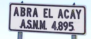
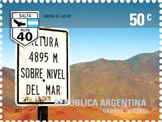
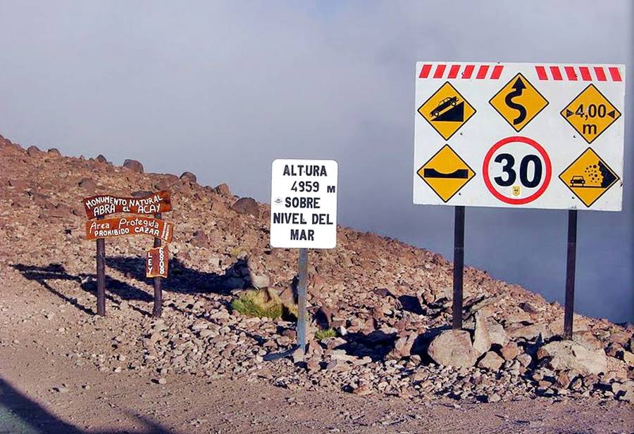
At the pass there is a road sign that has the 4,895 meters altitude written on it, but GPS measurements may give higher values. To make matters worse, there have been in the past, official road signs that stated that its elevation was 4,959 meters. Google Earth gives a reading of 4,952 meters.
Altitude Record
It is the highest road pass on a national highway in the world. And the highest one outside of Asia.
In case you are curious, the "Highest Road Pass in the World" is the pass of Semo La in centarl Tibet: it is 5,565 meters high or 18,258 ft.
The Highest Road Passes in the World
Thse are roads open to the general public, that link inhabited places and can be driven by regular vehicles (so highways for 4X4 vehicles and mining trucks and also seasonal highways are excluded). With this in mind, the highest highways on each continent are:
- 5,565 m (18,258 ft) Semo La, China. Asia
- 4,895 m (16,060 ft) Abra del Acay. Argentina. América
- 3,367 m (11,047 ft) Pico Veleta (ruta A-395), Spain. Europe
- 3,254 m (10,676 ft) Tlaeng Pass. Lesotho. Africa
- 2,228 m (7,310 ft) Mount Kosciuszko. Australia. Oceanía
Trivia
Fun Fact: The image below shows a road sign indicating an altitude of "4,859 m" instead of the correct figure: "4,895 m (Is it perhaps a case of dyslexia?)
Extreme altitudes: not much oxygen to breathe
Here, at Ruta 40’s highest point, air only has half the density that it has at sea level. Less density means less oxygen available and this entails the risk of Acute Mountain Sickness, known here as "Soroche" or "Apunamiento" (struck by the Puna).
How to get there
Q: How do you get there? Where is it on Route 40?
A: We detail how to reach it below. Also see our Ruta 40's Segment from San Antonio de los Cobres to Cachi webpage.

Driving across the Abra de Acay
From North to South, from San Antonio de los Cobres
Before setting off, we suggest that you check with the locals the road conditions along Ruta 40. Also register at the Police station just in case. They will go and look for you if you don't report at the Police station in La Poma, after crossing the pass.
You can drive a "short" route to the pass and back (88 km or 55 mi round trip), or drive south across it, to La Poma and from there to the town of Cachi (Son 191 km or 119 mi to Cachi - which has a service station).
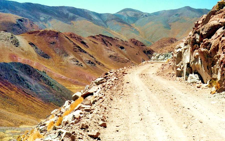
Except for the first part (to the Ruta 40 fork) and the final stretch between Payogasta and Cachi, which is paved, the rest of the road is gravel, dirt, sand and stones (which worsen as you climb up to the pass -see the photos).
This is the Map of the short trip, and this is the map All the way to Cachi.
Accommodation and Lodging > > San Antonio de los Cobres
San Antonio de los Cobres
Full details on the town of > > San Antonio de los Cobres [our Spanish language webpage]
Departure
Leave San Antonio de los Cobres and head towards the city of Salta along Ruta Nacional 40 & 51 which are paved. At km 13 - 8 mi leave Ruta 51 at the fork, and head right, southbound along Ruta 40 towards the Acay, La Poma and Cachi.
It is a narrow road, with a gravel surface and it is a mountain road with sections with a sheer drop-off on one side. It is not easy to drive and there are no towns, service stations or villages until you reach La Poma.
The highway climbs gradually and at km 32 - 20 mi. it reaches a place known as Casa Blanca, where the final climb up to the pass begins.
The highway zig zags towards the pass with switchbacks:
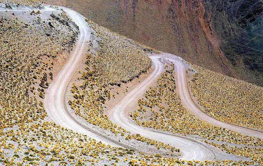
Abra del Acay
"One of the Top 10 Sights of Ruta 40".
Ruta 40 slowly climbs up to its highest point, which it reaches at km 44 - 27 mi: the famous Abra el Acay almost 5 kilometers (3.1 miles) above sea level.
Tips for driving the Acay
Advice given by one of our website readers:
(August 7 2013). "I drove from Cachi to San Antonio de Los Cobres, the journey was incredible and it took about four hours.
It is very important to register at the La Poma Police Station and then let them know at San Antonio de Los Cobres once you arrive (in case there are any emergencies).
I drove a 4x4 and I don't know if the road is suitable for cars, my pick-up was momentarily struck by altitude sickness, but I drove on, slowly. Some parts only allow one vehicle to go through at a time.
I understand that during the rainy season some sections of the road are cut off because you can see that you are driving along a river bed. I crossed
some melting ice and also iced parts, but my pick-up's weight broke the ice."
Descent from Acay into the "Valles Calchaquíes"
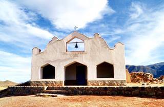
Church at El Trigal, Ruta 40. Raúl A. Balbastro
After the pass, the road goes down towards Esquina Colorada (km 67 - 42 mi), ahead is a place known as El Saladillo.
And at km 80 - 50 mi is El Trigal with its pictouresque church. Ahead, to your right is a gravel road that crosses the Calchaquí River and heads into (km 109 - 68 mi) the tiny village of La Poma (remember to inform the police that you crossed the pass).
It has very limited services and lodging, no fuel.
The Final Leg
Head back to Ruta 40 and continue until you reach Provincial Highway No.33 (paved) which links the Calchaqui Valley with the city of Salta along the amazing Cuesta del Obispo (a winding road from Puna to the jungle). Here at the tiny village of Payogasta the road becomes a normal two-lane paved highway. Drive south towards the town of Cachi. It is 58 km (36 mi) (of which 47 km - 29 mi are gravel) from Poma to Cachi.
Cachi has everything that you may need: lodging, fuel, hospital, restaurants and shops.
Accommodation > > Cachi
Cachi
Full details on the town of > > Cachi [our Spanish language webpage]
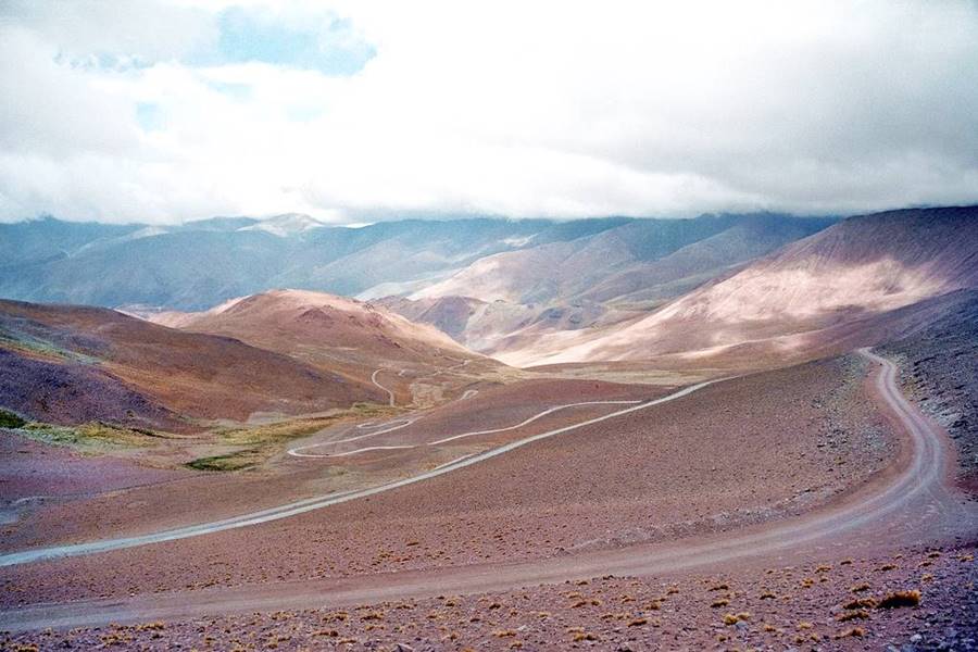
South to North from La Poma
La Poma is the last village before the pass, check with the locals the road conditions before heading north. Also register at the Police Station.
The road climbs next to the Calchaqui River, heading towards its sources. The highway goes by some scattered houses at El Trigal ("Wheat Field") and El Saladillo ("Salty one"). It goes by the place known as Esquina Colorada ("Red Corner)"
It crosses the Acay pass and then zig-zags its way down towards Casa Blanca ("White House") finally reaching National Highway 51 which links Salta city with the Chilean Border, through San Antonio de los Cobres.
It is paved here. Turn left and head west now along Highways 51 and 40, which overlap. After 11 km (7 mi) you will reach a lookout overlooking the town of San Antonio de los Cobres, which is 1 km ahead (0.6 mi). This town is located at an elevation of 3,774 meters (12,382 ft).
Drop by the Police station to tell them that you arrived safe and sound.
From San Antonio de los Cobres you can take the "New" Route 40 alignment north under the Polvorilla Viaduct, through Sey to Susques, or head north along the "Old" Ruta 40 to the Salinas Grandes Salt Flats.

Maps of the Abra El Acay
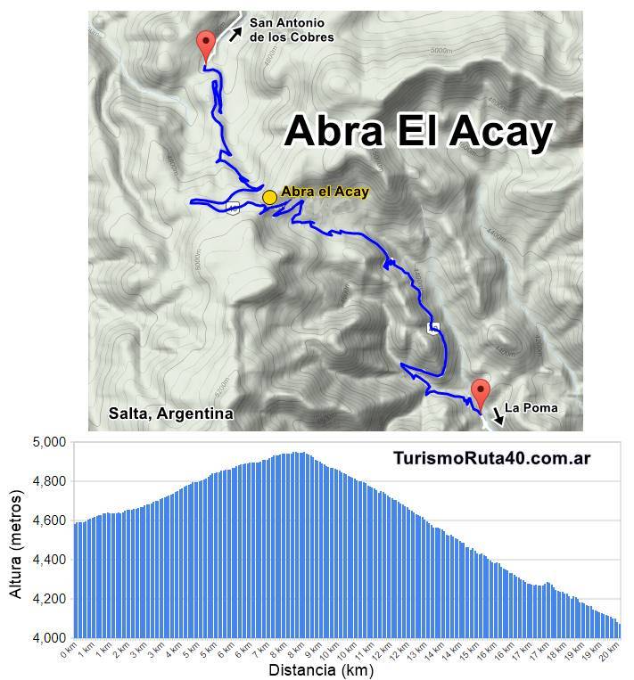
Elevation map of the Abra
The map below shows the Abra itself and the winding Route 40 highway, with altitudes:
Road map from Cachi to San Antonio de los Cobres through Acay
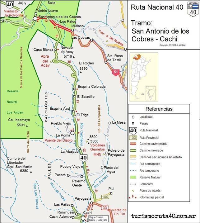
La Poma - San Antonio de los Cobres
Difficult unpaved mountain road
Distance: 90 km = 56 miles
Drive carefully, it is a high altitude winding mountain road. Its surface is not paved: it has gravel, dirt, sand and rocks with steep inclines. There are no villages, no gasoline and no lodging. The weather is tough year round.
The highway has a north to south direction crossing the Pass to link the Calchaquí River Valley in the south with the Puna Plateau highlands in the north.
See map from S. A. de los Cobres to La Poma.
Tips and Advice
1. The Weather
The Puna highland has an extremely dry climate with low relative humidity (averages less than 47%).
Rain is scarce: from 300 to 400 mm per year (12 to 16 inches). Rain falls during the summer, the rest of the year is the "dry season".
The low humidity and the altitude (+3,500 m - 11,500 ft) ensure a crystal clear sky, so the sun beats down on you relentlessly: protecte yourself from the UV radiation with a high SPF sunscreen.
Wind grows stronger in the afternoon. The weather in Cachi, San Antonio de los Cobres and the Puna is sunny and has a great temperature difference between day and night. It is a sharp contrast when you compare it with the balmy weather in the city of Salta.
This temperature differential between night and day is around 18°C (32.4°F). Nights are cold, even in summer.
During the winter the temperature is well below freezing point.
The rest of the year the temperature is also low: on average 8.6°C (47.5°F) with a median of 12°C (53.6°F) in Summer (Jan.) and 2.2°C (36°F) in winter (Jul.).
The highs are around 25°C (77°F) and the lows up to -15°C (5°F). It freezes during 220 days a yearr
2. When to Visit the Abra El Acay
Visit the Abra El Acay during the dry season, from April to November.
During the summer, late spring and early autumn it rains. The rainy season may provoke mudslides, flooding and road closure (November to end of March).
Winter has the disadvantage of the extreme cold and also ice may form on the road. It is very unlikely to encounter snow due to the dry climate.
Best time to visit is spring and autumn.
3. Altitude and Mountain Sickness
At elevations above 2.000 meters (6,500 ft) you may experience the unpleasant symptoms of Altitude Sickness, known locally as "Soroche" or "Apunamiento".
It is provoked by the low atmospheric pressure which in turn makes the air less denser, so there are fewer oxygen molecules in the same volume of air: you intake less oxygen when you breathe.
At the Acay Pass, at almost 5.000 meters altitude (16,400 ft), there is only 50% of the sea level oxygen content .
Lack of oxygen causes nausea, dizzyness, headache, fatigue, confusion.
Read more about how to mitigate Altitude Sickness
4. Safety Tips
This is a difficult road because it combines gravel, mountain driving, extreme altitudes and tough weather in an area with hardly any inhabitants and few villages to seek for assistance.
We suggest that you verify the road conditions before attempting to cross the Pass (you can do this at Cachi, La Poma or San Antonio de los Cobres).
Your car must be in top conditions and you should be adapted to the high altitude.
Fords, dry river beds and summer rain
There are many "dry" river beds that cut across the highway. These are dry most of the year but can become swift flowing rivers during flash floods in the rainy summer season.
Road Conditions
Check the road conditions on our website: Road Conditions.
Important Tips
- Keep your gas tank full (below we list the gas stations). Top it up before setting out, the distances are great and there are few service stations in the area, and they may have run out of fuel.
- Take food and water. Carry a paper map -don't rely on cellphone signal being available in the Puna.
- During the summer rainy season there may be road closures on Ruta 40.
- Cross the fords carefully especially during the summer flash flood season.
- This is a high altitude journey so factor in that you may suffer from Altitude Sickness.
- Wear apropriate clothes for the area (warm). Pack a blanket in case you have to spend the night out in the wilderness. Even in summer it can get very cold at night (large day to night temperature swings).
Loose Gravel. Drive carefully on the gravel, it is slippery, you can skid, the dust may impair visibility, passing vehicles may fling stones at your windshield (cracking, chipping or even breaking it. Take extra insurance when you rent a car).
There are service stations in San Antonio de los Cobres,Cachi, Jamas Pass, Cafayate, Purmamarca, Susques and Salta.
›› Location of Ruta 40's Service Stations
Further Reading - Sources
Google Map of Highest pass in the world (Tibet China).
The Postage Stamp: Correo Argentino, 2007.
Accommodation near the Abra El Acay
Find your room región
>> Lodging in the City of Salta
Hoteles in Salta along Ruta 40
North in Jujuy
South along Ruta 40
>> Find your hotel in the Province of Salta

