Valley of the Moon ⁄ Mars Valley
Last Updated: Austin Whittall
Cusi Cusi and the Valley of the Moon
"Top 10 Scenic Attractions along Ruta 40"
Learn All About It
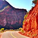
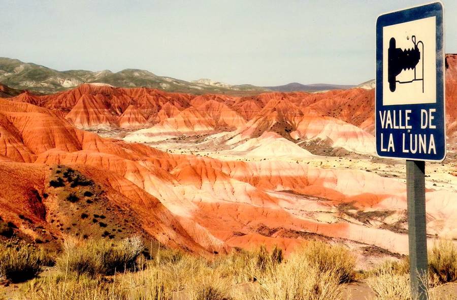
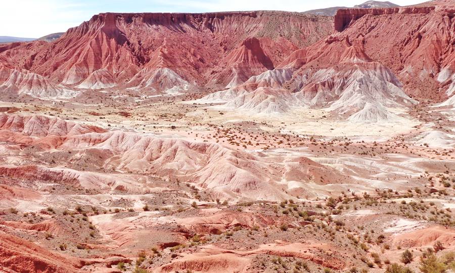
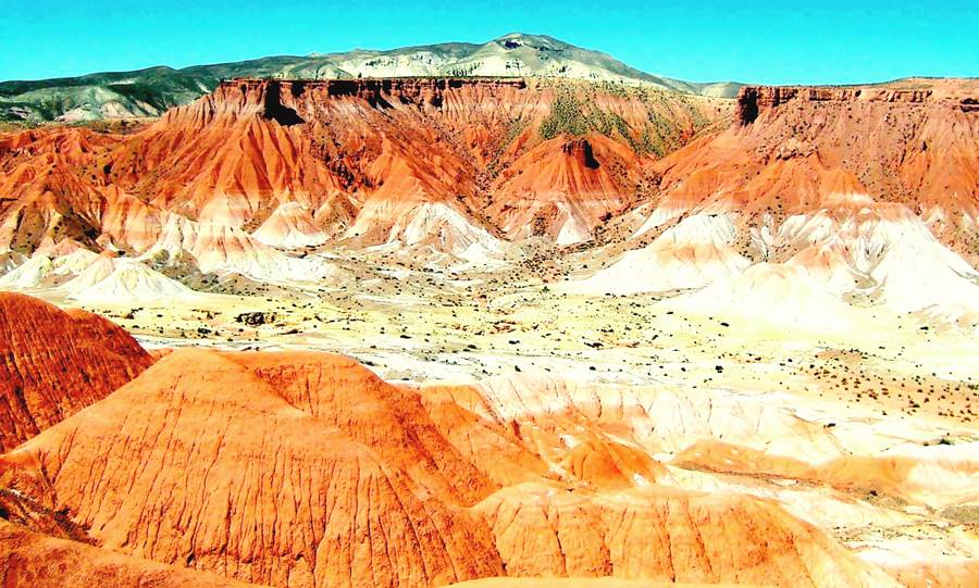
The Valley of the Moon or Mars Valley in Cusi-Cusi, Jujuy, is a multicolored valley eroded in the volcanic rocks of the Puna Highland, next to Argentina’s Ruta 40 highway. It gets its name from its reddish tinted sediments.
How to Pronounce Cusi Cusi in Spanish
The word "cusi" is pronounced "coo-see" so the place name is "coo-see coo-see".
Rodolfo Pace
Valley of the Moon
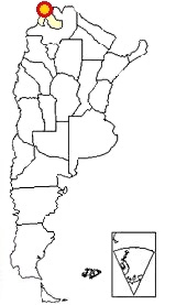
Cusi-Cusi is located the northwestern tip of Argentina -Red circle in this map
It located 5 km (3 mi) south of the village of Cusi-Cusi and is known as El Valle de la Luna which means "Valley of the Moon" in Spanish, and also (just to add a bit of confusion) as el Valle de Marte (or "Mars Valley").
Other places with the same name!
Don't mistkake this Valley of the Moon in Cusi-Cusi with its namesake in San Pedro de Atacama Chile where there are a "Valle de la Luna" and a "Valle de Marte". And, there is another "Valle de la Luna" located on Ruta 40 in San Juan province: the famous Ischigualasto provincial park, a UNESCO World Heritage Site.
What is it with people naming outlandish valleys after planetary landscapes?
Its name in the native Quechua language is "Puca Ukúqai" which very appropriately means "Red Valley".
What does Cusi-Cusi mean?
The strang name "cusi-cusi" which can also be written: "cussi cussi" and "kusi kusi" is a spider of the Salticidae family, known as Polybetes pythagoricus. A jumping spider that resembles a "tarantula" and which lives in the region.
Just as an example of the importance this spider has, see the 150 foot-long (46 m) spider drawn on the Nazca plain in Peru.
Getting There...
Cusi Cusi is located on Section #16 of Ruta 40
The northernmost section of the highway: from San Antonio de los Cobres to La Quiaca.
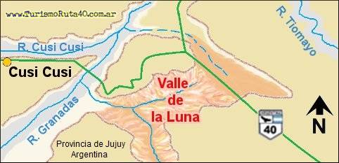
Its northern and eastern boundaries are marked Route 40, and furher east a dry river bed that flows into the Tiomayo River. To the west, a ridge separates the valley from the Granados River, and to the south it ends in some hills located between both rivers.
Its elevation is 3,800 meters (12,460 ft) above sea level.
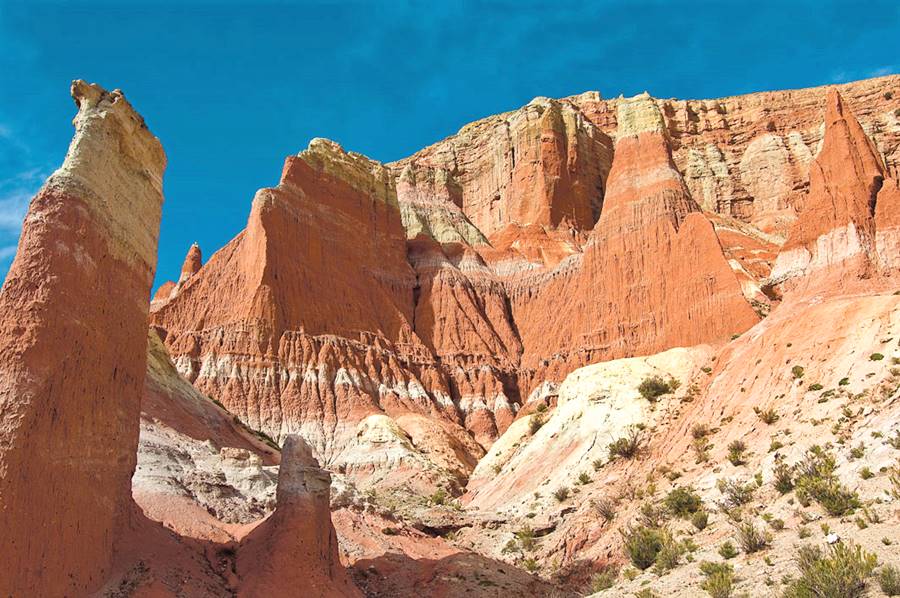
Its pinnacles stand over 100 m (310 ft) above the floor of the valley.
The color of its rocks ranges from white and gray to red and carmine. Mostly volcanic ash.
There are several spots along Ruta 40 overlooking the Valley, but you cannot drive into it from the highway.
Below is a Satellite view of the valley.
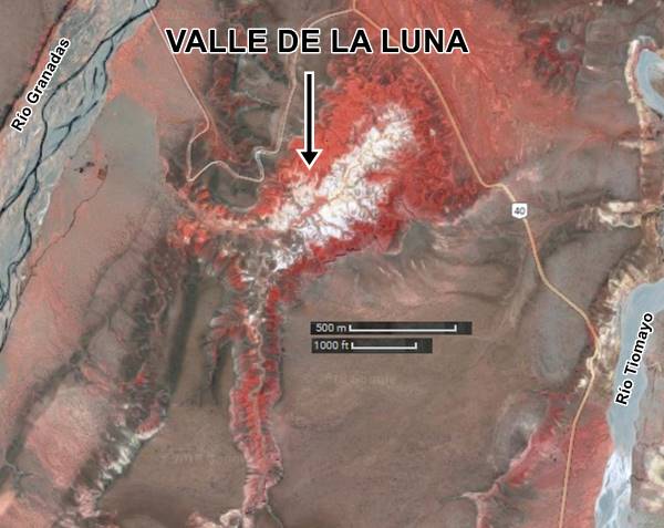
The valley is shaped like an inverted "L" which measures: on the NE-SW axis: 4,000 ft long by 1,500 ft wide. The other axis, which runs from north to south measures 3,300 ft.
Geology of "Mars Valley"
The origin of the red rocks
The layers of stone in the "Valle de la Luna" were formed at different times over millions of years. The uppermost layer is the youngest, and is known as the "Tiomayo Formation".
Tiomayo Formation
These rocks are layers of volcanic tuff known as "Cusi-Cusi tuff". They were laid down following explosive eruptions at the nearby Panizos volcanic complex. The ashes are between 6 and 12 Million years old.
In the area you can also find tuff from the Laguna de Pozuelos complex and pyroclastic flows, blending volcanic ash and pumaceous lapilli (Ignimbrites, from Coranzuli).
Volcanic Tuff
Tuff is a low density, porous rock formed by the "consolidation" (compacting) of volcanic ash ejected during a volcanic eruptions. They usually originate during pyroclastic events, which are explosive eruptions where a mixture of volcanic gas and very hot solid materials move along the ground at speeds of up to 120 mph.
The "Tiomayo Formation" overlies another older group of rocks, but these are not volcanic:
When the Andes mountains formed during the initial stage of the Incaic tectonic phase some 12 to 18 Million years ago, older rocks of the Santa Bárbara Group wore down, and the eroded sediments settled in basins located to the east of the newborn Andes. These were continental sediments formed in oxidizing riverine environments. They are known as the Peña Colorada Formation (or Red Cliff Formation).
Peña Colorada Formation
Made up of continental sediments that include sandstone and mudstone with colors that range from "red brick" and purple to gray and reddish. They have inclusions of white or gray-green volcanic tuff.
This formation's lowest layers has thick grained sandstone with gray, yellowish and red tints that are on average 150 ft. thick. They emerge as outcroppings here in Cusi-Cusi an in neighboring Paicone, whith a thickness of 230 feet.
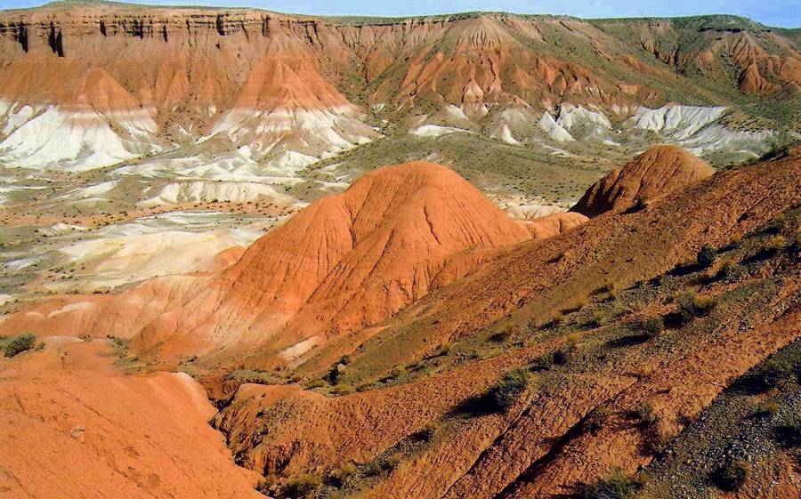
Beneath the red "Peña Colorada" rocks is yet another older formation:
Acoite Formation
It consists of an upper Cenozoic layer of rocks up to 500 m thick (1,640 ft).
These are marine sediments that form rocks of different types and tones: psammite (formed from sand) and pelite (formed from clays) with a gray color and lutite, or shale with dark tones.
These form clearly stratified layers of sediment up to 20 m (66 ft.) thick.
Rainfall over the course of the ages has eroded these rocks, exposing the underlying layers. The lack of superficial vegetation in the desertic plateau promotes erosion. The outcome is the magnificent valley that we see today.
The village of Cusi-Cusi
Cusi-Cusi is a small village with less than 250 residents. It is set on the southern bank of the Quebrada de Cusi Cusi River, close to where it meets the Granadas River.
Its inhabitants make a living by breeding llamas, mules and sheep or by working in the Mina Pirquitas mine. Some make local handicrafts (onix decorations or hand-woven ponchos and blanckets with sheep or llama wool).
More recently the production of Quinoa by the local co-operative, "Cooperativa Agrícola de Comunidades Andinas Limitada" or CADECAL has grown considerably.
Qinua o Quinoa
Quinoa Chenopodium quinoa is a plant that originated in the Andean region of South America and has been the traditional crop of the highlands since Prehispanic times
It is not a "traditional" cereal but it has all eight essential aminoacids necessary for human beings and it also has a very high 14% protein content.
The History of Cusi-Cusi
The Puna highlands have been inhabited for at least ten thousand years, and in more recent times, the local natives were farmers who also worked metals and domesticated the local llama and alpaca. They lived in stone homes with thatched roofs.
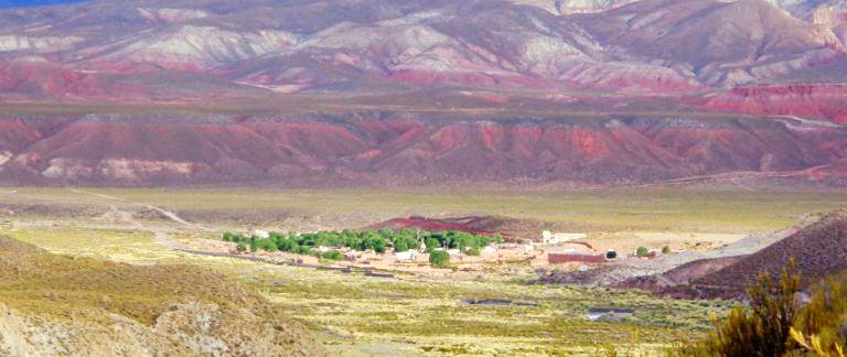
The Inca empire conquered the Puna around 1470 AD and built the The Inca Trail across the new territory to link it with the imperial capital in Cusco, Peru.
Inca Trail
UNESCO World Heritage Site
The "Inca Trail" or "Chapaq Ñan" is the Incaic imperial road network. It spans parts of Ecuador, Peru, Chile, Bolivia and Argentina.
Here, 4 km (2.5 mi) west of the village of Cusi-Cusi lie the ruins of a small farming settlement known as "Casas Quemadas" (or Burned Houses), it dats back to the Inka Period (1450 to 1536 AD), and it covered 2.4 km2 (600 acres).
There are roads leading from the ruins to the "Old Church" of Cusi-Cusi and from there you can see a well marked section of the "Chapaq Ñan". There is another road heading from the Puca Huaico ruins on the north side of the Cusi Cusi River heading towards the Guanapata Canyon and Paicone in the north. Another road heads south to Huasacucho Canyon and the village of Lagunillas ( or Small Lakes).
The Spaniards arrived in 1537, but were rarely seen in the distant and isolated Cusi-Cusi.
Then in the 1600s, the Marquessate of Yavi was created in the village of Yavi, Jujuy, home of the Marquis of Yavi or Tojo. They reigned over a vast area that encompassed the Puna region of Salta and Jujuy, part of the provinces of Tarija and Chuquisaca in Bolivia and all of the (now Chilean) Puna de Atacama.
During Argentina's Independence war against Spain, the last Marquis, Juan José Fernández Campero who was fighting on the Republican side, was captured by the royalists and jailed. He died in prison. But his land was claimed by a Bolivian army Colonel, Fernando Campero Barragán, who said he was the legal heir. Bolivia quickly absorbed the Marquessate and what is now Cusi-Cusi became Bolivian territory.
Argentina claimed this unlawful occupation and only ater the Pacific War (1879-1883) which pitted Chile against Bolivia and Peru did Argentina manage to negotiate with the victor (Chile), the return of the occupied territory.
Cusi-Cusi and the western part of the Puna of Jujuy, Salta and Catamarca were returned to Argentina in the late 1890s.
The village of Cusi-Cusi
The local shepherds lived close to the "Old Church" or "Vieja Iglesia" (which is located here - see this map).
The church is around 200 years old and the village around it was known as "Kakahara", but there was no space to expand the settlement so they moved 3 km to the east (2 mi.) to its current location.
The new town dates back to 1954 and only has two streets running along it, a church and a village square.
The Rivers: hidrology
The Valley of the Moon is the outcome of the erosion caused by rain falling on the relatively "soft" rocks located on the eastern bank of the Granadas River. The rainwater runs down from the valley into the Granadas river along an unnamed stream which is dry most of the year.
The Granadas River has its sources upstream of Cusi-Cusi and receives the inflow from several Puna rivers (like the Queñoal, River, where you can fish trout). Downstream it is known as San Juan del Oro River (Bolivia) or río Grande de San Juan.
It is part of the vast River Plate watershed, and its waters eventually reach the Atlantic Ocean after running along the Camblaya, Pilaya,Pilcomayo, Paraguay, Paraná and River Plate rivers.
Weather
The Valley is located at 3,800 meters above sea level (12,460 ft) in the Puna plateau. It has cold, dry weather, with strong winds and frost almost year round. It also has a very wide temperature swing between day and night. It is sunny most of the year except during the rainy summer period (Nov. to Apr.) when around 300 mm or 11.8 inches of rain fall.
The weather is extreme, with a mean annual average of only 7°C (44.6°F) in the lower areas. Below are some tips and advice on how survive in the Puna.
La Puna has a very dry climate with a very low relative humidity (on average 47%).
Dryness and altitude make for a very clear sky, so the sun is very strong (watch out for your skin and UV radiation, use a good sunscreen and dark glasses).
There is a great difference between daytime and nighttime temperatures of 18°C (32.4°C). Nights are cold even during summer.
During winter, temperature is well below freezing point.
Expect frost 220 days per year. The mean temperature during summer -Jan- is 12°C (54°F) and in winter -Jul- it is 2.2°C (36°F).
Getting there by Bus
There are tours from Humahuaca and also buses (Burgos bus company) from Abra Pampa on Ruta Nacional 9. It is a 125 km (78 mi) ride and it takes 4 hours.
Driving to Cusi Cusi
The Northernomost section of Ruta 40
The Valley of the Moon is located on the Segment from San Antonio de los Cobres to La Quiaca
This is a very difficult mountain road, gravel and dirt surfaced, it crosses many rivers using fords (not bridges).
Drive with care: it is a winding road, at high altitudes and has very few villages along it and no gasoline except at Susques and its end and starting points. The weather is tough.
See the maps below from Susques to Cusi Cusi and from La Quiaca to Cusi Cusi:
Tips and Advice
1. When to visit the "Valle de La Luna" in Jujuy
Visit the area during the dry season, from April to November.
During the summer, late spring and early autumn it rains. The rainy season may provoke mudslides, flooding and road closure (November to end of March).
Winter has the disadvantage of the extreme cold and also ice may form on the river fords It is very unlikely to encounter snow due to the dry climate.
Best time to visit is spring and autumn.
2. Altitude and Mountain Sickness
Cusi-Cusi is located at 3,800 meters (12,460 ft) so you may experience the unpleasant symptoms of Altitude Sickness, known locally as "Soroche" or "Apunamiento".
It is provoked by the low atmospheric pressure which in turn makes the air less denser, so there are fewer oxygen molecules in the same volume of air: you intake less oxygen when you breathe.
At 3,800 meters atmospheric pressure is only 65 kPa and the oxygen contect is barely 64% of the sea level oxygen levels..
Lack of oxygen causes nausea, dizzyness, headache, fatigue, confusion.
Read more about how to mitigate Altitude Sickness
3. Safety Tips
This is a difficult road because it combines gravel, mountain driving, extreme altitudes and tough weather in an area with hardly any inhabitants and few villages to seek for assistance.
Your car must be in top conditions and you should be adapted to the high altitude.
Fords, dry river beds and summer rain
There are many "dry" river beds that cut across the highway. These are dry most of the year but can become swift flowing rivers during flash floods in the rainy summer season. They also freeze in winter so be careful with the ice and frost.
Road Conditions
Check the road conditions on our website: Road Conditions.
Important Tips
- Keep your gas tank full (below we list the gas stations). Top it up before setting out, the distances are great and there are few service stations in the area, and they may have run out of fuel.
- Take food and water. Carry a paper map -don't rely on cellphone signal being available in the Puna.
- During the summer rainy season there may be road closures on Ruta 40.
- Cross the fords carefully especially during the summer flash flood season.
- This is a high altitude journey so factor in that you may suffer from Altitude Sickness.
- Wear apropriate clothes for the area (warm). Pack a blanket in case you have to spend the night out in the wilderness. Even in summer it can get very cold at night (large day to night temperature swings).
Loose Gravel. Drive carefully on the gravel, it is slippery, you can skid, the dust may impair visibility, passing vehicles may fling stones at your windshield (cracking, chipping or even breaking it. Take extra insurance when you rent a car).
There are service stations in Susques, La Quiaca, Humahuaca, San Antonio de los Cobres, Jamas and Purmamarca.
›› Location of Ruta 40's Service Stations
Accommodation in Jujuy
Find Lodging
>> Accommodation in La Quiaca
Lodging along Ruta 40 Jujuy
Jujuy, close to Ruta 40
>> Find your room in <Provincia de Jujuy

