All you need to know about the Perito Moreno Glacier
Last Updated: Austin Whittall
Glaciar Perito Moreno Facts
Learn All About the glacier
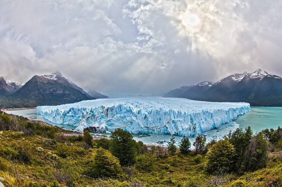
The Glaciar Perito Moreno glacier is located in the southwestern tip of Argentina, near the town of El Calafate in Santa Cruz province, Patagonia, Argentina.
It is set in the forested Andean mountains, at the southern end of the vast Continental Ice Field on the Lago Argentino lake.
It advances relentlessly until it forms an ice dam across the deep Canal de los Tempanos channel, sealing off the southern arm of the lake.
Water level grows and water pressure increaes until the ice dam is ruptured in a fantastic natural spectacle.
Some FAQ about the Glaciar Perito Moreno
All you need to know about the glacier:

Where is it?
Q: Where is the Glaciar Perito Moreno?
A: It is located in the Patagonia, in the province of Santa Cruz, near the town of El Calafate (note that it is not close to Ushuaia and it is not located in neighboring Chile).
Map showing the exact location of the Glaciar Perito Moreno.
Some more geo data:
It is located at an elevation of 590 feet (180 meters, above sea level. Its GPS coordinates are Lat: -50.471766, Long:-73.038125.
Closest town to the glacier
Q: Which is the closest town?
El Calafate is nearest town to the glacier:
El Calafate
Full details about > > El Calafate [see our Spanish language webpage]
Entrance Fee
Q: How much does the National Park's entrance fee cost?
A: There are different entrance fees depending on your place of residence (local residents, residents of Santa Cruz Province, Argentine citizens, foreign visitors, students and pensioneers).
You can buy the entrance ticket at the Argentine National Parks website.
You can also buy it at the entrance gate at Río Mitre (credit card Visa, Matercard, Visa debit or cash).
Open Hours
The park access is open: from 8 AM to 6 PM from Sept. 1 until Easter. After Easter and until Aug. 31, it is open from 9 AM to 4 PM.
Getting there
Q: How to get to the Glaciar Perito Moreno?
A: By car, from El Calafate, fully paved highway: along Ruta Provincial N° 11. The distance is 76.5 km. (Map showing directions).
There is a bus service and of course excursions and tours from El Calafate to the glacier.
El Calafate is accessible from Ruta 40 by car, and you can also fly to El Calafate or take a long distance bus. (Read more: How to reach El Calafate: flights and bus.)
Best time to visit Perito Moreno Glacier
Q: When to visit the Glaciar Perito Moreno?
A: The Los Glaciares National Park and the Glacier can be visited throughout the year. Winter weather is more extreme (rain, snow, sleet, clouds, wind, ice and frost). But you can visit the glacier despite the winter weather (June to Septemper).
The ideal time of the year is spring, summer and early autumn (fall), from September to April, because it is not so cold.
Read more about Weather at the Glacier.
Due to its extreme southern latitude (in the "Roaring Forties"), cold, windy and rainy days -including snow- can occur anytime during the year, even during summer.
What is so special about the glacier
Q: Why is the glacier so famous?
A: The glacier is unique because it is the only one in the world to advance periodically and seal off a lake.
In its advance it forms an ice dam blocking the outflow of the Lago Argentino's southern arm, causing water to build up, lake level to rise and pressure build up against the ice wall.
The glacial dam fails, rupturing in a formidable natural event, as the southern arm of Lago Argentino empties northwards dragging enormous blocks of the former ice dam.
Read more about ice dam and rupture.

Trivia: The westernmost tip of Argentina
The parking lot by the glacier is the westernmost point in all of Argentina which is accessible by car.
It is located at 73° 01' 48" W Longitude.
To go further west, you'd have to walk a few miles across the mountains and glaciers to the Chilean - Argentine border.
Complete information on the Glaciar Perito Moreno
Weather at the Glaciar Perito Moreno
The weather at El Calafate is very different from the weather at the Glaciar Perito Moreno
The weather in the Patagonian Andean foothills is very unstable and variable. Temperate in summer and cold in winter. Very damp. It rains throughout the year. Snow falls during the cold winter months (starting in Fall). Wnd is stronger during summer.
The nearest town to the glacier, El Calafate, is located 50 miles east. It is set in the drier Patagonian steppe where rain is infrequent and less snow falls in winter.
Temperature
At the face of the Glaciar Perito Moreno the maximum mean temperature during summer is 63°F (17°C) and the average low temperature during winter is below freezing: 28°F (-2°C). The annual mean is a cool 45°F (7°C).
Rain and snow
Rainfall increases as you approach the Andes, so it may be a warm sunny day in El Calafate and raining heavily at the Glaciar Perito Moreno. Annual rainfall is around 35.5 inches (900 mm).
Wind is strong, cold and persistent. It pushes the massive icebergs that calve off the glaciers (there are many other glaciers apart from the Perito Moreno).
Tip
Carry warm waterproof clothes with you because the weather can change without any warning -even in summer.
The glacier's name: Perito Moreno
Francisco Pascasio Moreno explored and gave its name to the Lago Argentino lake. He was also the first person to navigate it in 1876-77.
He sailed up its northern shore up to the "Devil's mouth" (Boca del Diablo), crossed to its southern shore navigating the "Channel of the icebergs" (Canal de los Témpanos) and hoisted the Argentine flag at Punta Bandera (which in Spanish means "Flag Point") in March 1877.
He didn't mention the glacier that now bears his name but his map shows the peninsula that faces it (Península de Magallanes) and the southern arm (Brazo Rico) of lago Argentino lake. The Red arrow in the ancient map below shows the position of the Glaciar Perito Moreno).
"Perito" Moreno
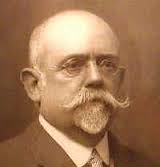
Francisco Pascasio Moreno
Francisco Pascasio Moreno was born in Buenos Aires in 1852. He was an explorer and scientist who in the 1870s ventured into the until then unknown reaches of Patagonia.
He crossed Northern Patagonia from the coast, reaching what are now Bariloche, Cholila and Esquel. He was captured by the natives and escaped death by braving the Limay River rapids on a raft.
He explored Southern Patagonia: Santa Cruz, La Leona and Shalia Rivers, lakes Argentino, Viedma and San Martín.
He served as the Head of the Argentine Border Demarcation Committee, which settled in an amicable and peaceful manner the border dispute between both countries. His position here, as an expert ("Perito" in Spanish), is the origin of the prefix attached to his name.
He helped the native people return to Patagonia and re-settle there after the military campaigns in 1879-83 that had dislodged them.
He donated land ceded to him by the Federal Government, as a reward for his services as a "Perito", deeding it towards the creation of Argentina's first national park (Nowadays the "Nahuel Huapi National Park").
Later he was elected as a Representative (Diputado) in the National Congress' House of Representatives. Passing away in 1919.
The National Park close to Ruta 40, a lake near the city of Bariloche, the town which marks the end of this section of Ruta 40, and the famous Perito Moreno Glacier are all named after him.

Map of lago Argentino, drawn in 1877 by F. P. Moreno
Recent History
Although this area has been inhabited for over 10,000 years (visit the "Cuevas del Gualicho" or "Walichu Caves" near El Calafate to see ancient rock art), it was only during the last decades of the 1800s that the area was explored and charted.
The first reference of the Glaciar Perito Moreno was written by Lieutenant Alfredo Iglesias in a hydrographic survey conducted in 1901.
However the German scientist R. Hauthal, member of the Argentine Border Commission, headed by Moreno himself, named it that same year as "Bismarck Gletcher" (Bismark glacier), after the then Chancellor of the German Empire. English explorer Hesketh Pritchard called it "Iceberg glacier" during his 1901 expedition.
Again, in 1909, Swedish explorer and scientist Carl Skottsberg called it "Bismark".
In the end, and after Moreno's death, it became known by its current name: Glaciar Perito Moreno.
Relic from the Ice Ages
Vast ice sheets over 1 ¼ mile thick (2 km) covered the Andean summits in this region during the Ice Ages that took place over the past two million years.
The glaciers advanced east, beyond El Calafate and the eastern tip of Lago Argentino, well into the Patagonian steppe.
This period ended some 12,000 years ago, and the ice sheet began to melt, and nowadays the ice sheet survives in a smaller area along the border between Chile and Argentina, where the altitude and winter snowfall replenish the glacial ice.
Glaciers and the Patagonian lakes
The glaciers advanced and retreated many times during the past 2 million years. They followed the tectonic depressions and valleys .
They acted as gigantic bulldozers, excavating the valleys even deepr and wider and pushing the rocks they removed eastwards, forming large morraines in the steppe.
When the ice melted, the meltwater filled in these deep depressions formiong the Andean lakes (Argentino, Viedma, San Martin, just to name a few).
The most recent morraines dating back 12,000 years ago can be seen at the eastern tip of Brazo Rico arm of Lago Argentino, at the arroyo Horqueta creek and also at Punta Bandera.
Patagonian Ice Fields

Cold weather and heavy snowfall have preserved two large continental ice fields in Patagonia. They cover an area of 8,110 sq. mi. (21.000 km2).
They are, after the ice fields in the Antarctic and Greenland, the largest in the world.
They are located between 47° and 51°30' S upon the 73° W meridian. The Northern Patagonian Ice Field is located in Chile, and the Southern Patagonian Ice Field, is shared by Argentina and Chile (see map, where they are marked in violet, in yellow, is the maximum extension of the glaciers during the Ice ages. And in red the glaciers' range 10,000 years ago.
Southern Patagonian Ice Field
The Southern Patagonian Ice Field is protected in Argentina by the Parque Nacional Los Glaciares (Glaciers National Park), and one of these glaciers is the Glaciar Perito Moreno.
Glaciar Perito Moreno: main features
Physical information
Facts Sheet
The glacier's sources are located at 50°S. It is born on the continental divide, within the Southern Ice Field, on the border between Chile and Argentina, on the eastern flank of Cerro Pietrobelli, at an altitude of 9,672 ft. (2.950 m). From there it flows eastwards and ends at the Canal de Los Témpanos in the Lago Argentino lake, facing the Magallanes Peninsula.

Height comparison, man and Perito Moreno Glacier
- Altitude: 613 ft. (187 m) above sea level, which is altitude of Lake Argentino.
- 18.6 mi. (30 km): Maximum length.
- 2.7 mi. (4.4 km): Maximum width between Reichert Range and Cerro Moreno.
- 3.1 mi. (5.0 km): Glacier's width along its front.
- 88.8 sq. mi. (230 km2): Surface area.
- 197 ft. (60 m): height above the water level at the Canal de los Tempanos.
- 6.5 ft. per day (2 m ⁄ day): is the speed velocidad of the glacier's central section.
Size of the Glaciar Perito Moreno
From the walkways facing the glacier you can only see the upper part of the glacier, the part that is above the Lago Argentino.
The glacier doesn't float on the lake, it rests on the lake bed, far below the surface. It is really big:
- Far into the Andes, 4,4 miles west (7 km) -see the image below, the glacier is almost 2,300 feet thick (700 m).
- Most of this ice is below the lake's surface, so in the distant future, when the glacier has melted away, there will be a western arm of Lago Argentino lake here, over ¼ mile deep (400 m).
- In that place, the lowest part of the glacier is actually 656 feet (200 m) below sea level.
- The "Iceberg Channel" (Canal de los Témpanos) is "U" shaped and very deep: 525 ft. (160 m).
- To the south, the lake's Brazo Rico arm has an irregular bottom with a maximum depth of 330 ft. (100 m) - see image below.

Ice thickness and depth below lake level

Cut of the Glaciar Perito Moreno. It stands 60 m above water level, and 100 m below it on Brazo Rico.
What does it look like?
It has a white-bluish color and has a low quantity of morraine rocks in comparison to Upsala or Ameghino glaciers. These are the rocks that the ice rips off the lateral valley walls and form dark lines on the glacier's surface.
It has a very rough surface with many cracks, crevasses, seracs (ice columns) and caves. The melting ice forms ponds on the glacier's surface (see photo below).:

How the Glacier formed
The making of a glacier

Internal structure of a glacier.
This is how a glacier is formed:
- Accumulation: snow falls and accumulates all over the glacier, part of it melts, the rest doesn't: Perennial snow builds up in the Accumulation Zone.
- Ice formation: successive layers of snow compress those beneath them, degassing the air and compacting them until they become New Ice.
- Movement: The mass of ice rests on the rock slopes of a mountain. The slope and gravity cause it to move downhill. The pressure of the weight of the ice plus the friction against the rock heats the ice melting it (even below freezing temperature). The water lubricates the ice - rock interface speeding up the downhill movement of the glacier.
- Melt: The glacier is a slow-motion river of ice that melts when it enters the Calving Zone where higher temperatures (found at lower altitudes) evaporate superficial and frontal ice.
- Front: The Frontal Zone acts like a bulldozer pushing the rocks shaved off the bedrock beneath the glacier. This forms a wall of broken stone in front of the glacier known as the Terminal Morraine.
As the front of the Glaciar Perito Moreno is partially submerge in the lake, you can't see its terminal morraine.
Critical factors for glacial formation
So that a glacier can form, two critical factors are needed: abundant snow and low temperatures:
The Snow
The Pacific coast of Southwestern Patagonia receives 276 inches of precipitation (7.000 mm) each year and the central part of the Southern Ice Field gets 157 inches (4.000 mm) yearly.
This drops off quickly as you move east, El Calafate is arid and only receives 8 in. (200 mm) of snow and rain per year.
Snow and rain falls year round on the Ice sheet and builds up as snow, which feeds the Ice Field and the glaciers.
Cold
For ice to form, the temperature in the Accumulation Zone of the glacier must be below freezing point (32°F - 0°C.
The sources of the Glaciar Perito Moreno glacier, above an altitude of 2,780 feet (850 m) have a mean temperature below freezing point. In summer you have to go higher (4,920 ft - 1500 m) but even so, the mountains there are even higher, which ensures a good supply of snow and ice for the glacier.
The dinamics of a glacier
All glaciers melt but if more snow falls than the ice that melts, the glacier will grow thicker and wider, just like what happened during the Ice Ages.
Si el glaciar se derrite rápidamente y pierde más masa que la que recibe, se achicará en volumen, longitud ⁄o ancho (tal como sucede con la mayoría de los glaciares del mundo debido al Cambio Climático).
If input of snow equals the melt off, the glacier will remain stable (this is the case of the Perito Moreno glacier.
The front of the Glaciar Perito Moreno has a mean annual temperature of 45°F (7°C) meaning that it melts there.

NASA
Equilibrium or stasis of Perito Moreno Glacier
The Glaciar Moreno está is in a state of stasis or equilibrium despite the movement of its frontal area (the cycle of damming and rupture).
That it is in stasis means that its length, width and thickenss are roughly constant and that the loss of ice on its frontal zone is compensated by the ice building up in its accumulation zone.
Glaciar Moreno's Mass Balance
The glacier melt releases 35.3 Billion cu. ft. of water (1 km3) each year into Lago Argentino, roughly 40% of this is in the form of icebergs, and the remaining 60% is melt water.
However the glacier does not retreat, on the contrary, it is in stasis with some advances of its frontal zone.
Snow buildup
The glacier recovers all this amount of water (35.3 Bn cu. ft) each year because it has a very large Accummulation Zone (upper left part of the image above), which is equivalent to 67% of the glacier's surface. It is also quite high and therefore below zero throughout the year.
The movement of the glacier
The glacier moves forward at a speed of around 6.5 ft per day (2 m per day) in its central part. The sides move slower due to the friction with the slopes of the mountains that enclose the glacier. Here the speed is 1 to 2 ft. per day (30 to 60 cm per day).
The ice takes 34 years to cover the distance between its sources and the glacier's front.
It calves large icebergs into Lago Argentino, 70% fall into the Canal del los Tempanos, the other 30% fall into the Southern Arm, known as "Brazo Rico" (Rico Arm).
Stasis and forward movement cause the famous damming of the Rico Arm of Lake Argentino.
Dam and Rupture Cycle
The glacier's most singular aspect is that it advances slowly eastwards until the frontal face of ice collides with the rocky shorline of the Magallanes Peninsula, forming a dam across the Lago Argentino.
The ice dam
The Perito Moreno is different from other glaciers in the area, for instance the Glaciar Upsala (whose frontal area floats in the lake's water without resting on its bed): The Perito Moreno glacier rests on the bed of lago Argentino lake.
So as it pushes eastwards it acts like a gigantic "lock" across the Canal de los Tempanos Channel, gradually sealing off the southern arm of Lago Argentino.
Closure: a dam
As it rests on the lake bed, the ice forms a hermetic seal, with its front lodged against the rocks and its base dug deep into the bottomo of Lago Argentino, the water to the south is sealed off from the rest of the lake.
The tip of the glacier is a few hundred meters wide at the point of contact with the eastern shores of Lago Argentino.

www.santacruz.gov.ar
Southern Arm of the lake: "Brazo Rico" arm
The southern arm of Lake Argentino, is known as Brazo (Spanish for arm) Rico, and it has only one outlet: northwards through the Canal de los Tempanos Channel.
Ice melt from the mountains that surround this arm, and the melting of the Glaciar Perito Moreno's southern face (on the Brazo Rico) raises the water level south of the ice dam.
The Glacier istself has a wide frontal area, some 3 km (almost 2 miles) to the north of the dam, the dam itself, a few hundred yards wide, and the southern face of the glacier, on Brazo Rico arm, 2 km long, which is roughly 1 and ¼ miles long.
Flooding
The dammed southern arm floods the lower areas along its coastline and you can see, when the water level is "normal" a strip of land without trees along the shore. This is because the flooding kills the trees.
Flood levels have reached considerable depth above the normal lake level: 49 feet in March 1942 (14,9 m) and 62.3 ft. (19 m) in 1988. The "dead zone" along the shore hints at a maximum lake level variation of over 75 feet (23 m).
Rupture of the dam
The dammed water builds up enormous pressure against the ice wall, this causes the dam to fail and break apart:
- Hidrostatic pressure of over 40 feet of water starts to crack the ice.
- Marginal channels form and fill with water. Liquid water contributes to melting the dam.
- Pressure builds up against the narrowest part of the glacier (the frontal dam).
- A tunnel is formed, and it bores across the dam, as the water enters the tunnel, it widens it, and the ice starts to crack and the dam collapses.
- The dam wall is breached and the water flows northwards causing a flood surge in the northern side of the lake.
- The outflow of the Santa Cruz River (outlet of the Lago Argentino's basin) reaches an peak of over 21,500 cu. ft ⁄ sec (2.000 m3⁄s), three times its normal maximum flow.
Historic record of closures and ruptures
When it was first discovered in the late 1800s, the front of the glacier was almost half a mile east of the coastline of the Península de Magallanes and the Canal de los Témpanos Channel was much wider than it is today.
The first known closure took place in January 1917, when the glacier's frontal zone moved eastwards closing this gap.
1934-35; was the second documented closure. The third took place in 1939-40, causing the level of Rico arm to reach 38 ft (11.5 m) above its normal level. This dam flooded some of the "estancias" located on the southern and eastern side of the Brazo Rico. The Argentine Navy bombed the ice dam but was unable to breach it.
List of Closures
There is no fixed pattern to the closure and rupture cycle:
1917, 1934, 1939, 1942, 1946, 1952, 1953, 1966, 1970, 1972, 1975, 1977, 1980, 1984, 1988, 1990, 2004, 2008, 2012, 2013 (two events), 2016 and 2018.
It is possible that climate change and the warming trend it provokes, influences this ice dam closure and rupture cycle.
Images of the Rupture of the Ice Dam
Follow sequence from left to right and downwards:


Image Credits: photo 1, A. Whittall, 2 to 5, La Nación (See the video), 6: Clarin
Perito Moreno glacier and Climate Change
Global Warming's negative impact
- Climate change has reduced the surface area of the Southern Patagonian Ice Field from 5,214 sq.mi. (13.500 km2) in 1944 to 4,828 sq.mi. (12.500 km2) in 2009.
- The volume of ice is decreasing rapidly, and accelerating over the last few years: up to 9.3 cu.mi. of ice each year (38,7 km3 per year).
- The ice is thinning out at a speed of over 3.3 ft. per year (1 m) contributing to an increase in sea level of 0.4 hundredth of an inch (0.1 mm) each year.
- Most of the glaciers in this ice field are retreating the exceptions are: Pio XI glacier (in Chile) and the Glaciar Perito Moreno; both are advancing.
Plants and Wildlife
The forests of the Magallanes peninsula, and the mountains that surround the glacier are mainly southern beeches (nothofagus) like the lenga, ñire and the guindo. This is genus of Southern Hemisphere trees that dates back to the ancient continent of Gondwana: they also grow in New Zealand.
You will also find foxes and different bird species, including the magnficent condor. The endangered Patagonian deer, the huemul is protected in the Parque Nacional Los Glaciares national park
The Glacier's insect: Andiperla Willinki

Andiperla willinki, lives in the glacier's ice
Insect that lives in the cracks of the glacier
The Andiperla willinki is a peculiar insect that belongs to the order of the Plecoptera; its common name is "Patagonian dragon".
This order is found throughout the world and comprises over 1,500 species which represent the most primitive winged insects.
The "Dragon" belongs to the Gripopterygiidae family and was discovered by the French biologist Aubert Willink in 1956 (hence its latin name).
It differs from the other members of the order because it lacks wings. Instead of tiny ocelli (eyes) it has large ones, which allow it to see well in its dark habitat.
You can find it under the stones of the Patagonian Andes. It also lives in the extreme glacial environment of the Southern Ice Field and in the ice of the Upsala, Viedma and Moreno glaciers.
The Andiperla is just over three quarters of an inch long (20 mm) and spends all of its life eating the small algae that grows inside of the glaciers' ice.
Its body produces an antifreeze substance based on glycerol to keep it from freezing to death (this is similar to the one you put into your car's radiator).
They also lack empodia (tiny claws at the end of their legs), a feature which they share with another member of the order, the R. nudipes which also lives in cold mountain areas. Perhaps it is an adapatation to cold environments.
Getting to El Calafate & the Glacier
Reaching the Glacier
First you have to get to the town of El Calafate: the glacier is 47 mi (76 km) west of it.
By Car
El Calafate is 1,285 miles (2.070 km) as the crow flies from Buenos Aires. If you want to drive there along paved roads, it is a 1,720 mile drive (2.770 km).
Read our Tips : how to get to El Calafate by car.
By Bus
There are different bus lines linking El Calafate with other towns:
To Bariloche and to Río Gallegos you can go by TAQSA ⁄ MARGA
There is another bus to Bariloche along Ruta 40 runs from Nov. 15 to April 15 : Chalten Bus.
Fly to El Calafate
It is a flight of 3 hours and 15 minutes from Buenos Aires to El Calafate.
Aerolíneas Argentinas and LATAM fly to El Calafate from Buenos Aires. Check with the airlines the dates and timetables (LATAM does not fly during the winter low-season).
Driving to the Glacier from El Calafate
It is a fully paved itinerary. 154 km round trip. There is gasoline in El Clafate, but no other service stations along the road.
The glacier is located on Ruta 40's Section 3 that links Río Turbio with Tres Lagos
See the Map with directions.
Leave downtown El Calafate, km 0 and head west along Av. Libertador San Martín (RP 11), the road runs along the southern shore of Bahía Redonda (Round Bay).
As you head west, the the steppe becomes more humid and you will see grass.
At km 21 after crossing the bridge of the río Centinela River is Estancia Alice. One km after the estancia's main buildings, to the south is RP 60 (a dirt track) that goes to Estancia Anita and RP 15.
Tips for an uneventful visit
Some tips for a safe trip and minimum environmental impact.
- Snow and Ice. In winter, check the road conditions before leaving town. Ice may form on the road surface. Use chains if necessary, take some warm clothes, food and water.
- Speed. Respect the speed limits and avoid roadkill.
- No Hunting. Hunting is forbidden in the national park.
- Minimum environmental impact. You cannot take pets into the park. Don't pick flowers, stones, wood. Don't light fires. Stay on the trails. Take your litter back home with you (Leave no Trace).
The road runs along the slopes of Mount Frías (3,590 ft. - 1.095 m). Ahead you can see the first trees of the Patagonian forest on the mountains of the Magallanes Peninsula. At km 40, junction:
Access to Puerto Banderas
To the right (north) is the highway (RP 8) that leads to the port of Punta Bandera (9 km away), this is where the lake navigation excursions depart from (to the Upsala, Spegazzini and Mayo gaciers).
Road to the Glacier
To the left, southwards, is the highway that heads towards Lago Argentino's Brazo Rico arm. The road crosses the río Mitre River (km 45). By the bridge is the gravel road that leads to the southern side of the Brazo Rico and goes all the way to Lago Roca lake.
Brazo Rico Arm of Lago Argentino lake
The road turns right, westwards and runs along the northern shore of Brazo Rico, heading into the Magallanes peninsula. Now you enter the Nothofagus forest and reach the access gate of the national park. Pay the fee here or show your tickets (if you bought them online).
Los Glaciares National Park
The "Parque Nacional Los Glaciares" (which means "Glaciers National Park"), was established in 1937. In 1942 it was expanded to include the shoreline of the Canal de los Témpanos and the northern coastline of Lago Rico.
It is a UNESCO World Heritage Site.
Effects of the Glaciar Perito Moreno ice dam
As you drive west along Brazo Rico, see the bare area between the edge of the forest and the lake: no trees grow here due to the flooding caused by the ice dam.
In the image below you can see it: it is the dawrk line between the turquoise colored lake and the green forest.
At km 67, after the La Curva de los Suspiros ("curve of sighs" or also "balcony of sighs") you get the first glimpse of the Glaciar Perito Moreno along the western side of lago Argentino.

A. Whittall
The road continues west, and at km 70 is the port Puerto Bajo de las Sombras, where you can take the Tours to the Glacier (navigation and hike or trek on the ice).
Finally, at km 76 is the lower parking lot next to a second port, whith restrooms, restaurant. The road continues up to the upper parking lot where the walkways are located.
You will not be able to drive further west than this point in all of Argentina
Tours at the Glaciar Perito Moreno

Hiking on the Glacier. Adiel lo
There are different types of tours that you can do here, at the Glacier:
Excursions on the Glaciar
Check out these excursions and tours in El Calafate, there are several operators and tour ⁄ travel agencies including the transfer to the glacier and back.
Plan of the Glacier's Walkways

The Walkways
There are different circuits that let you see the glacier from different angles ad heights. Bear in mind that the lake surface is 590 ft (180 m) above sea level and the upper parking lot is 980 ft. (300 m high).
Don't run along the walkways, they may be slippery due to rain, snow or ice.
Don't touch the trees, plants, flowers, stones or branches. Don't feed the wildlife.
Stay on the walkways. Don't try to go beyond them. It is for your own safety.
Don't approach the glacier: tourists have lost their lives due to ice falling from the face of the glacier. It is VERY DANGEROUS.
There is an elevator for people with reduced movility but it only leads to the upper walkways. The rest of the circuit has steps.
Use warm and waterproof clothes Weather is unpredictable it can rain or get very cold and windy, even in summer.
Visiting the Glaciar Perito Moreno itself
Walking on the blue ice!
Check out the options in El Calafate, compare prices and what they offer.
Mini Trekking on the Glaciar

Trekking on the Glacier. Source
From August to June. For people aged 10 to 65. It requires some effort, so it is not adequate for pregnant women.
You board a boat at the port of Bajo de las Sombras, cross the Brazo Rico arm and reach its Southwestern shore after 20 min. sailing.
You are given information on the tour, you are given crampons (check out previously what type of shoes you should wear) to walk on the ice.
It is a 2 hour trek on the glacier. Take sun glasses and warm clothes.
Hike into the Glaciar
From September to end of April. For people aged 10 to 50. It is a 7 hour tour. Difficult.
Same as the mini trekking but you walk up the southern morraine for 1 hour to the glacier, where you put on crampons and then hike for 3.5 hours.
Navigation in front of the glacier

Navigation by the Glaciar Perito Moreno. interpatagonia.com
Brazo Rico
This is a 1 hour navigation along the Brazo Rico arm of Lago Argentino lake, with views of the southern front of the glacier. Check timetables and if you can buy tickits without booking them in advance at the Puerto Bajo de las Sombras port (6 km east of the walkways).
Canal de los Témpanos Navigation
Leaves from Puerto Perito Moreno on the north side of the glacier. Departs every hour between 11 AM and 4 PM. One-hour navigation in front of the glaciar along the Canal de los Témpanos.
Tips and Advice
Safety Tips for Road Trips
When driving in Patagonia remember to:
- Fill your gasoline tank at every service station, distances are great and you may not always find a gas station at the small towns.
- Carry food, snacks and water
- Warm clothes, even during summer. It can get cold and it is always windy.
Reaching Calafate via Ruta 40
El Calafate is linked to Ruta 40 throuhg the paved Ruta Provincial 11 (distance: 32 km). It is located on the section from Río Turbio to Tres Lagos, north of this small town there is an unpaved section before you reach Gobernador Gregores, north of this town it is completely paved.
Ruta 40, towards the north is paved all the way to Tres Lagos and to the south, it is paved to Río Turbio, there is an unpaved section east of this town en route to Rio Gallegos.
You can also reach El Calafate from Ruta Nacional 3 in Río Gallegos (313 km away).
Driving Ruta 40 in this area
Ruta 40 in Patagonia crosses the arid steppe, few towns or places to get assistance or help. Winter is cold, wind strong and can really push your vehicle around.
Snow is not too common on the steppe but it can fall heavily. Ice is another issue during winter.
Loose Gravel. Drive carefully on the gravel, it is slippery, you can skid, the dust may impair visibility, passing vehicles may fling stones at your windshield (cracking, chipping or even breaking it. Take extra insurance when you rent a car).
Road Conditions
Check the road conditions on our website: Road Conditions.
There are service stations in El Calafate, Río Turbio, Rio Gallegos, Esperanza, Tres Lagos, Gobernador Gregores.
> > Location of Ruta 40's Service Stations
Accommodation near the Glaciar Perito Moreno
There are plenty of hotels in El Calafate.
>> Your room in El Calafate
Accommodation on Ruta 40 in Santa Cruz
>> Your hotel in Santa Cruz Province

