Ruta 40's first leg
Ruta 40 its southernmost section
Argentina’s Ruta 40 begins at the Cabo Vírgenes Cape, which is its "zero" milepost, on the Atlantic Ocean a few miles north of the Strait of Magellan. This segment is mostly unpaved (gravel road), and crosses the Patagonian steppe, ending at the city of Río Gallegos, capital of Santa Cruz provinc.
Southernmost tip of Patagonia
1st Section of Ruta 40
Map of this Section of Ruta 40
>> Interactive Map of Ruta 40 in Santa Cruz
The map of the leg between Cabo Vírgenes and Río Gallegos.
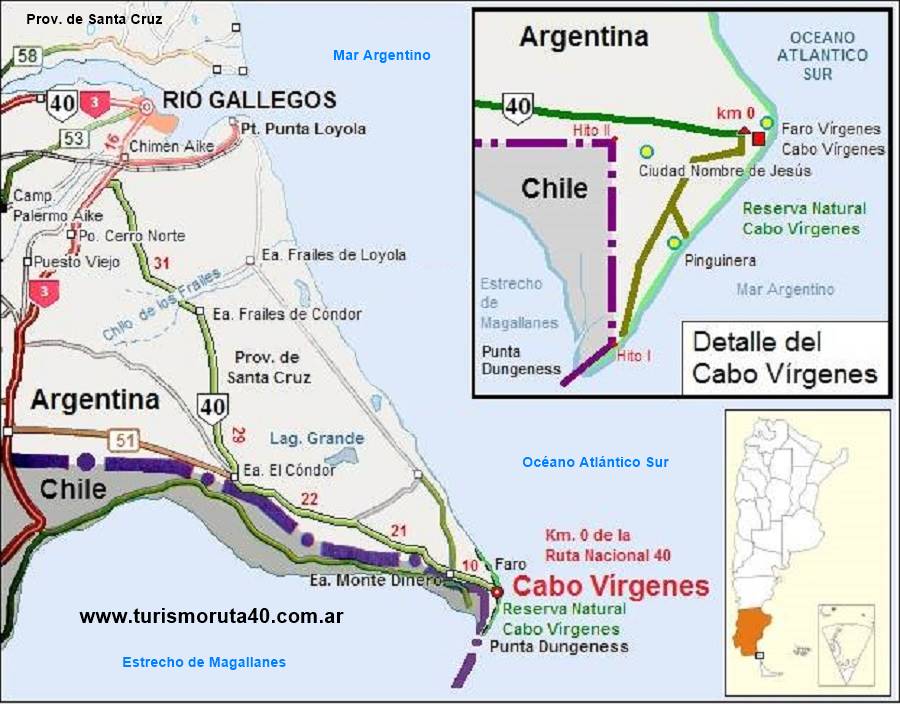
Description of Section # 1
The southernmost point of Continental Argentina
To go further south, you have to cross the Strait of Magellan into Tierra del Fuego Island. This Cape and Punt Dungeness headland, are the southernmost part of Argentina's territory on the South American mainland.
Ruta Nacional 40 begins here, in this isolated place at the cape of Cabo Vírgenes, on the eastern tip of the Strait of Magellan.
The cape is only 9 km (5.6 mi) north of Punta Dungeness. The southern point of Argentina's coast along the Atlantic Ocean, and the northeastern opening of the Strait of Magellan.
The cape of cabo Vírgenes is located in Patagonia, in the province of Santa Cruz.
This is really south! From here to the Antarctic there are only 1,221 km (759 mi).
Kilometer Zero of Ruta 40: Cabo Vírgenes
Until 2004, the Ruta 40 had two sections, and both started in the city of Mendoza. One headed north and the other south, the latter ended near Cabo Virgenes, at Punta Loyola Point, on the mouth of the Río Gallegos estuary.
But on November 24 2004, both alignments of Ruta 40 were unified and the zero milepost was moved 124 km (77 mi.) further south to its current location.
So the Ruta Nacional 40's Kilometer Zero (Km. 0,00) is located in Cabo Vírgenes, Patagonia.
Below is a photograph of the "zero kilometer" milepost, this is an "official" Argentine National Highways Directorate marker (the historic lighthouse can be seen behind it):
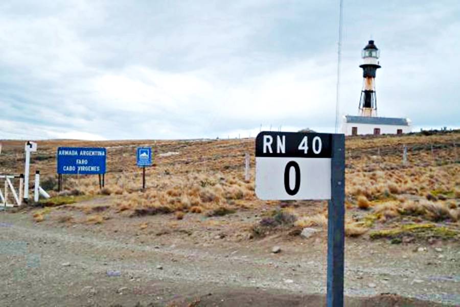
Description of the Section (C. Vírgenes - Río Gallegos)
Comment about Ruta 40 in Santa Cruz
Argentina's National Highways Directorate informed that they arbitrarily assigned the "km 100" marker to Routa 40 at Punta Loyola, and that the final alignment of the highway from there to Cabo Vírgenes is (quote) "interrupted", in other words, not built.
Nevertheless, in our website we describe the alignments of Ruta 3 and Provincial Ruta 1 as that of Ruta 40, because they are the only possible way to reach Cabo Vírgenes.
Leaving Río Gallegos
To reach Cabo Virgenes you must take the same road in a round-trip journey. Leave the city of Río Gallegos (km 0) along San Martín Ave. heading south (Here Ruta Nacional 3 and Ruta 40 overlap).
Detour: Visit Punta Loyola
When you reach km 10.3 Ruta 40 turns left towards Punta Loyola which is located on km 40. Este es el Mapa to Punta Loyola.
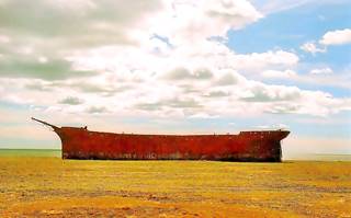
You can drive on, around the point and after 6 km (3.7 mi) you will reach the shipwrecked Marjory Glen.
Shipwreck in Patagonia
The ship was built in 1892 and caught fire here, in 1911. Two of its crew died in the fire and the rest abandoned the ship, which washed up on the shore (see photo).
Retrace your course to head back to Ruta 3, and at the junction, turn left and go south.
Onwards to Cabo Vírgenes
We will use the mileage from Rio Gallegos. Cross the tracks of the narrow gauge Industrial Railroad built to carry coal from the mine at Río Turbio to the port at Punta Loyola.
At km 15,4 a fork to the left that leads to Cabo Vírgenes along Ruta Provincial 1. Take it and leave Ruta Nacional 3, which continues south, towards the Chilean border.
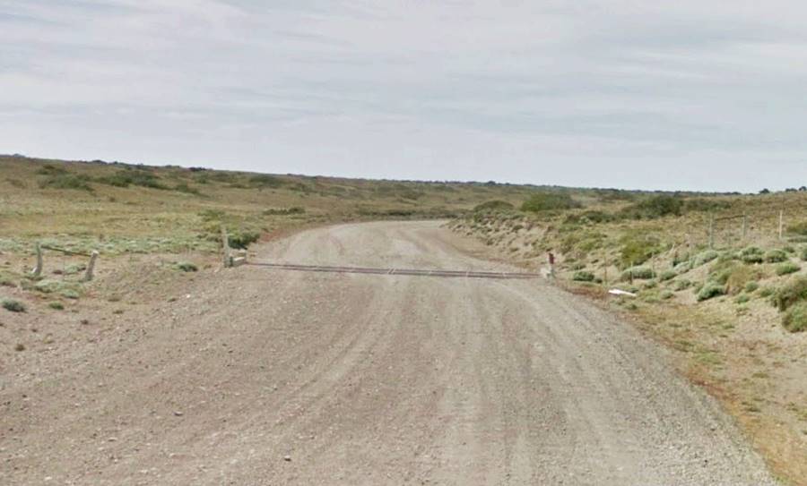
Ruta Provincial 1, a provincial highway, begins with a short paved section, but very soon becomes a gravel surfaced road. It is a wide and relatively smooth road without steep inclines. It has a general NW to SE course.
The road crosses the souther range of the Patagonian steppe, and the shrubs and bushes lie close to the ground to face the strong winds (coirón, calafate, mata verde and mata negra). At km 40,2 after crossing the Chorrillo de los Frailes stream, to your left is the ranch Estancia de los Frailes. At km 70 the road turns east and runs parallel to the Chilean border.
Here, to your right is another ranch, Estancia Condor and ahead, at km 85 is a gas treatment plant from the rich gas and oilfields of the Magellan region.
Keep driving and at km 113 on the south side of the highway is the Estancia Monte Dinero, a working sheep ranch which also offers accommodation to guests at the ranch house, built in 1880 and which overlooks the Magellan Strait:
>> Find lodging near Cabo Vírgenes
At km 123 to your right, is another processing plant, "Bateria Recepción Magallanes", belonging to the JV of Argentina's YPF and Chile's ENAP. The underground pipelines from the oil and gas wells in the South Atlantic merge here for treatment.
Just ahead, at 125 km Ruta 1 forks to the south, heading to Punta Dungeness. Take the left fork, and just 1 mile ahead (km 127) you will reach the historical Punta Vírgenes Lighthouse and the Kilometer zero of the Ruta 40.
Google Map
> > Map of Section 1 from Río Gallegos to Cabo Vírgenes.
Cabo Vírgenes Cape
A "Cape" is a headland extending into the sea. Cabo Virgenes was discovered by Magellan on October 21, 1520 during his expedition which was the first to sail around the world. His chronicler, Antonio Pigafetta wrote in his diary: "On the day of the eleven thousand virgins we entered a strait, the cape of which we named the Cape of the Eleven thousand virgins".
He was referring to Saint Úrsula who was martirized together with her companion, Undecimilia, in Cologne, Germany by Attila the Hun. They had refused to surrender their virginity. "Undecimilia" which was later taken to mean "eleven thousand" in Latin...hence the "eleven thousand" virgins. Nowadays the cape's name in Spanish means "Virgins' Cape".
Ruta 40 in Cabo Vírgenes, Fun Facts and Trivia
- It is the lowest point of the whole highway: almost sea level.
- It is the only place where the Ruta 40 is close to the ocean.
- It is the southenmost point of the highway, but, it isn't its easternmost point despite being on the sea coast. That honor goes to its northernmost point, La Quiaca.
The Lighthouse at Cabo Vírgenes
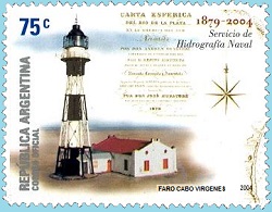
The historical building was erected in 1904. It is a steel tube which contains a ladder. It is supported by a lattice of steel pipes.
It is Mide 26,5 meters tall (87 ft.) and stands 69,5 m (228 ft.) above sea level, its light can be seen for 44 km (27 mi).
The image shows an Argentine mail stamp issued in 2004, depicting the lighthouse.
Visi the Museum of the Universidad Nacional de la Patagonia Austral, that is next to the lighthouse.
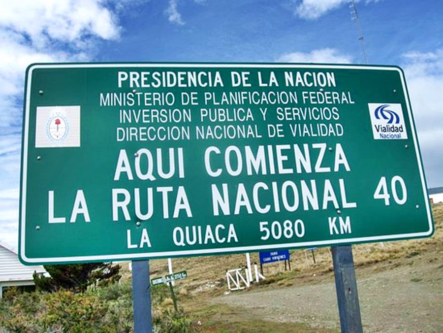
Kilometer Zero Sign
The sign marking the "Km Zero" is shown below. The length of Ruta 40 is incorrect, it is longer than 5,080 km:
Punta Dungeness Point
Drive south for 9 km (5.6 miles) along the gravel surfaced Ruta Provincial 1, and you will reach the northeastern mouth of the Strait of Magellan. This is Punta Dungeness, named so by British naval officer Samuel Wallis in 1766, after its namesake in Kent, England.
On the Chilean side of the point is the Punta Dungeness lighthouse built in 1899 and the first marker of the Argentine-Chilean border, "hito 1", to the south, barely visible is the Island of Tierra del Fuego.
The first settlement in Patagonia
Sarmiento de Gamboa founded the first "town" in Patagonia in 1584, and named it "Nombre de Jesus" (Name of Jesus). Its remains have been found next to the cliff close to the Cabo Virgenes lighthouse.
The site is known as the Valle de las Fuentes and a monument marks the place.
The lack of food drove its inhabitants to move out shortly after it was founded. They went to the village of "Rey Don Felipe" close to the location of modern Punta Arenas (Chile). The residents of both cities starved to death and only one man survived, to be rescued by Drake a few years later.
Natural Reserve and Penguin Colony
Open seasonally, daily, from 8 AM to 8 PM. Admission fee charged.
It was established in 1986 as the Wildlife Reserve of Cabo Vírgenes to protect not only the penguins but also the historical sites at the cape.
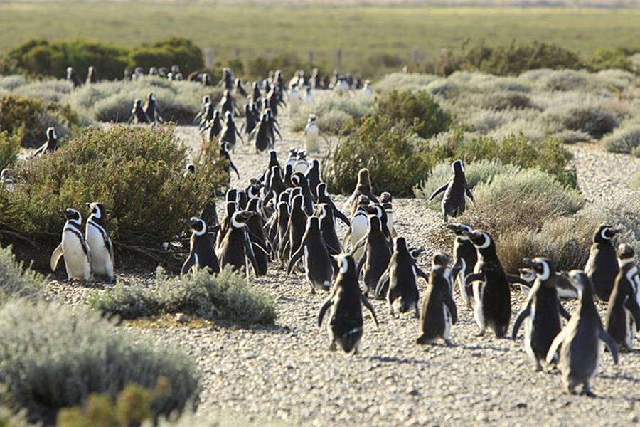
It is an ideal place for watching the penguins: during summer, the colony has over 150,000 breeding couples of Magellanic Penguin (Spheniscus magellanicus), who choose this spot to court and lay their. It is the Second Largest Penguin Colony in South America.
Tips and Advice for a Safe Journey
1. Weather: Patagonia's Roaring Forties
The weather is cold with a mean annual temperature of 6 °C. (almost 43°F), closeness to the sea makes it more moderate than further inland. Technically it is a cold oceanic semi-arid climate with scarce rainfall (approx. 260 mm or 10.5 inches yearly) which fall regularly year round.
Summers are cool and winters cold, with frost and also snow. Lowest temperature on record was -20,2°C (-4°F) and the highest during summer was 35°C; (95°F). The average for winter is 1,5°C (34.7°F) and for summer 14°C (57.2°). The climate is dry, with a relative humidity of 60%.
Westerly winds blow constantly and average 50 km⁄h (31 mph) with gusts of up to 100 km⁄ (62 mph), it is one of the windiest places on Earth.
2. When to visit the area
Visit Cabo Virgenes between November and April, it is the warmest time of the year.
3. Safety Tips
Very Important: bear in mind that there are no towns or fuel along this section of Route 40. You must fill up your gas tank in Río Gallegos before leaving. Take adequate gear with you.
Ruta 40 crosses the steppe here, the distances are great and there is no fuel along the way. It can get very cold here in winter. Winds are strong, drive carefully and be aware of sudden gusts
Snow is not all that frequent but it can snow a lot and it freezes during winter, with frost.
Most of the road is gravel surfaced be on the look out for stray stones -if you rent a car, buy window breakage insurance.
Road Conditions
Check out our website to learn about the current: Road Conditions along Ruta 40.
Important Tips
- Fill up your gas tank (see where, below) before setting out. There are no gas stations along the highway to Cabo Vírgenes. Fill yout tank in Río Gallegos.
- Take food and water and a paper map.
- Carry warm clothes and a windproof jacket, even in summer. Patagonia's weather is unpredictable and very tough. Wind chill drops the temperature.
- A blanket or sleeping bag and a small gas heater come in handy in case you have to spend the night on the road.
Gravel Road. Drive carefully on the gravel roads, you can skid and breaking distance increases.
There is fuel in Río Gallegos
›› Location of Ruta 40's Gas Stations on Ruta 40
Accommodation in Santa Cruz
Find your hotel along Ruta 40 in the province. Cities listed from north to south:
>> Lodging in Cabo Vírgenes
Hotels along Ruta 40 in Santa Cruz
>> Find your room in Santa Cruz province

