Ruta 40 Section 10
Ruta 40 in the Wine Region
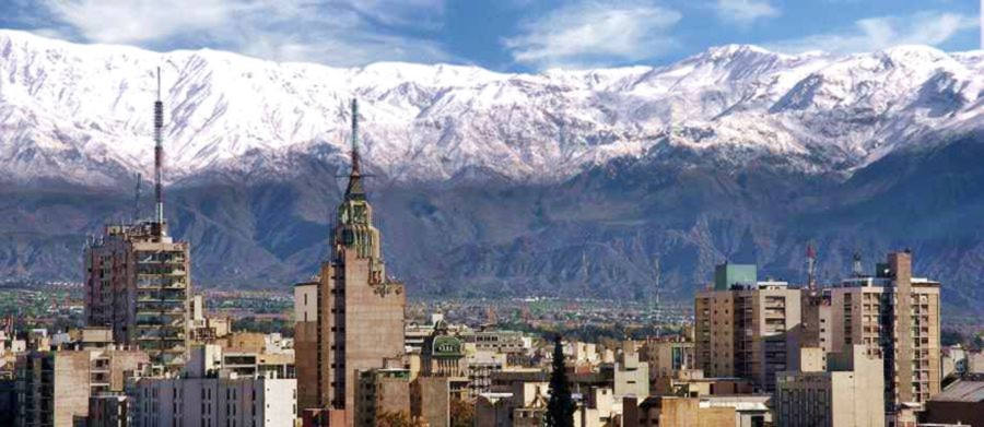
This section of Ruta 40 crosses the vineyards and wineries of the Valle de Uco, going through Tunuyán, San Carlos, and close to Tupungato. It extends into the renowned wine-producing terroirs of Luján de Cuyo and Maipú, reaching the City of Mendoza, the provincial capital.
It is the access to the Andes that tower close to 6,000 meters high (19,000 ft.) and to Mount Aconcagua. This International pass leads to Santiago, Chile, Uspallata, and the Christ Redeemer of the Andes.
Enjoy your Ruta Nacional 40 roadtrip in Mendoza, Cuyo Region, Argentina
A Summary of this Road Section
It covers a distance of 124 km (77 mi.). Of which 77 km are freeway (48 mi.)
Fully paved section.
Heights along the road
- 1,088 m (3,570 ft). At the beginning of the section in Pareditas.
- 764 m (2,507 ft). At the end of the section in Mendoza City.
Highest spot along this leg
Pareditas is the highest point of this section, the highway runs along the Tunuyán River and then the divide that leads to the Mendoza River and climbs up into the provincial capital.
Map of this Segment of Route 40
Interactive Map of this Segment of Route 40
>> Interactive Map of Ruta 40 in Mendoza

Section 10 in Mendoza
See red box in map
10th Section
Ver este mapa Google map del tramo.
Other related maps of the area:
- North of Mendoza
- North and Central Mendoza
- Wine Region of Alto Río Mendoza
- City Center, Mendoza City
- Maipú
- Greater Mendoza South, Luján de Cuyo
- Potrerillos
- NW Mendoza, Andes
- Valle de Uco San Carlos, Tunuyán, and Tupungato
- El Sosneado to Pareditas
- El Sosneado
- Malargüe and Bardas Blancas

Pareditas: starting point
Pareditas has around 2,500 residents and provides all the necessary services for the traveler, gasoline, hotels, healthcare.
Pareditas
Full details on the town of > > Pareditas [our Spanish language webpage]
>> Find your Hotel in Pareditas
We describe this section from South to North, beginning at the city of Pareditas and ending at Mendoza City [our Spanish language webpage]

It is located on the southern tip of the fertile Valle de Uco and is a rural, farming, and wine-producing region. It is well known for its oregano and aromatic herbs production.
Leaving Pareditas
From the center of the town (km 0) take Ruta Nacional 40 northwards and enter the Valle de Uco valley, famous for its wines, vineyards and fruit orchards..
> > Find your Hotel in the Valle de Uco

At km 3 you pass by Chilecito and 5 km ahead is Tres Esquinas.
Eugenio Bustos
> > Find your hotel in Eugenio Bustos
At km 19, is Eugenio Bustos on the Ruta 40 and, to the right, is the access to the city of San Carlos (3 km to the east):

San Carlos
Founded on Oct. 3, 1772, it is the head of the oldest Department in Mendoza Province. San Carlos and Eugenio Bustos are the main cities.
San Carlos Fort
The remains of the fort are a National Historic Monument (NHM). Built in 1770 by San Carlos Creek to defend the City of Mendoza from the raids of the local natives. It was named for Carlos III, King of Spain.
It is said that General José de San Martín met here in a conference with the native chiefs in 1816 so that they would ensure a safe passage for part of his army who would cross the Andes through the territory they controlled, to liberate Chile from the Spaniards.
Onwards to Tunuyán
Continue northbound, at km 20 crossroads with Prov. Hwy. RP 92 that links San Carlos and La Consulta. The highway runs along the Valley of the Tunuyán River, which can be seen from the road in some sections.
> > Find your Hotel in La Consulta

To the east are the Huayquerías del Guadal, an arid region that is a sharp contrast with the lush and irrigatedValle de Uco. A Huayqueria is a dry desert-like terrain crossed by dry gullies called huaycos or "huadis" (see picture above).
Ruta 40 crosses an irrigated area, with poplars, woods, and farms. This is an apple-growing area which are collected in Fall.)
At km 27, junction (left) with Prov. Hwy RP 95 from La Consulta. At km 37 bridge across the Tunuyán river. At km 40 you enter the city of Tunuyán:
Tunuyán
This is the largest and most important city in the Valle de Uco, it is the head of Tunuyá Department. It was established in 1880 and is known as the Capital of the Apples
, which are grown and processed here into juice and cider.
There is a fishing club in Tunuyán with a lake and a campground.
The name Tunuyán
According to Perón in his 1935 book, it is a Mapuche language word that means "dangerous country that shakes", alluding to the earthquakes that can be felt in the region. Diego Bigongiari, however, says it is a Huarpe native word meaning "underground waters".
Tour along the Tunuyán River
From the city, drive along Prov. Hwy. 92 which takes you to the wineries in the towns along the river towards the Andes: Colonia Las Rosas, Los Sauces, Vista Flores. Take Highway 94 to the foot of the Cordillera at "Manzano Histórico". A wine-tasting tour to enjoy the local wines.
>> Find your hotel in Vista Flores

After leaving Tunuyán, at the junction with Provincial Highway 96, the expressway begins, known as "Autovía 40", it is one of the few sections where the Ruta 40 is a divided multi-lane highway. It continues into and across Mendoza City. At km 50 you reach Zapata, access point to Tupungato (23 km - 14 mi.) towards the Andes.
Tupungato
Tourist city with wine-tasting tours in NW Valle de Uco, at the foot of the mountains.

The Name Tupungato
It could be the Huarpe word Temongacu meaning "lookout to the stars" or "Condor watching point", it could also come from Putun-cátu: "height that reaches the heavens".
Acceso to Tupungato from Ruta 40
From Zapata you can drive west (left), leaving Ruta 40 along Prov. Hwy 88, and after 23 km (14 mi.) reach the bustling town of Tupungato.
Final Leg into Mendoza
From km 50 in Zapata, you will start seeing the oil pumps close to the highway. The dry gullies fill up with snowmelt in summer and feed the Tunuyán River. At km 70 you reach Anchoris.
At km 82 is the community of Ugarteche. To the east Prov. Hwy 16 heads off to the Reservoir Embalse El Carrizal and westwards Prov. Hwy. 86 goes towards Tupungato (38 km) along the Cerrillos Road.
The "Old" Ruta 40
In Ugarteche Provincial Highway 15 forks to the left, to the NW. It was the original alignment of Ruta 40 into Mendoza. Below it is pictured in Agrelo.

>> Find your hotel in Agrelo
Intersection with the highway to the Cristo Redentor Pass
At km 95 interchange with Ruta Nacional 7 that heads west towards Uspallata and the high Andes to the border with Chile and the International pass of Christ Redeemer (Cristo Redentor) and also to Parque Provincial Aconcgua, the provincial park of Aconcagua, the highest mountain outside of Asia.

Access to Luján de Cuyo
Proceed nortwards along Ruta 40 hacia, at km 101 bridge across the Mendoza River.
Just ahead is the access to the city of Luján de Cuyo, on the easwt side of the freeway.
This city and its vineyards are known as Land of Malbec (lTierra de Malbec).

Access to Maipú "Cuna del Vino" (The Cradle of Wine)
Ahead, at km 106, interchange with Prov. Hwy. 60. At km 109 fork along Calle E. Civit - Hwy 10) leads Maipú, 5 km to the east (3 mi.), which is known as La Cuna del Vino - the Cradle of Wine (See the Wine tours in Maipú).

Ruta 40 heads north and enters the suburbs of the Greater Mendoza.
At km 124 it reaches Mendoza City.
End of this leg.
Mendoza
This is the capital of Mendoza Province, and one of Argentina's most important cities. It has many sights, landmarks and tour options.

Next Leg: To San Juan
See the Next Leg, from Mendoza City to Guandacol in San Juan province.
Tips and Advice to drive this leg

1. The Weather
- Summer. Hot. Daytime temperatures are high. Very dry. This is the rainy season, summer storms, torrential rain, even hail.
- Winter. Cool during the day, cold at night. No rain, clear sky. Frost in the countryside. Excluding the July winter holidays and school recess, it is a low season for travel.
- Fall and Spring. Pleasant during the day, cool at night, little rain. The end of summer and early fall is the grape harvesting or "vendimia".
2. When to drive this leg
You can visit Mendoza the whole year.
3. Precauciones
This is an easy segment, totally paved, mostly freeway. Be careful with cyclists, pedestrians and slow moving farm vehicles. It is a relatively flat and straight alignment.
If you plan on driving along mountain roads (to the Aconcagua) or other highways in the Andes, take note that they are winding, mountain alignments (heavy truck traffic to and from Chile). Other roads are gravel surfaced. Drive carefully.

Road Conditions
Check it at our Road Conditions Ruta 40 webpage.
Tips
- Take paper maps, water and food.
- If you will be visiting the Andes, take a blanket and warm clothes, hat, even in summer.s/p>
- Dry climate, low relative humidity, drink water and keep hydrated!
There is fuel in Pareditas, San Rafael, San Carlos, Tunuyán, Tupungato, Maipú, Luján de Cuyo and the Greater Mendoza
›› Learn more about Service Stations along Ruta 40

Lodging on this Section of Ruta 40
Find your hotel in any of the cities in the region:
Book your room
>> Accommodation in Mendoza City
Hotels in Mendoza City and surrounding area
Lodging in Luján de Cuyo
Hotels in the Valle de Uco
Accommodation in the South
>> Find your hotel in Mendoza Province

