

Ruta 40 Section 11
Ruta 40 in Mendoza y San Juan
This section of Ruta 40 crosses the north of Mendoza and all of San Juan province. It passes through the oasis of Tulum Valley and the San Juan vineyards and wineries.
It is completely paved and includes mountains, expressway, large cities, and the natural arid scenery of Cuyo Region.
The leg ends in the tiny town of Guandacol in La Rioja's south-central region.
Enjoy Ruta Nacional 40 in Mendoza, San Juan and La Rioja, Cuyo, Argentina

A Summary of this Road Section
- Starts in Mendoza City (Mendoza)
- Ends in: Guandacol (La Rioja)
- Total Distance: 432 km (268 mi).
- Roadway: fully paved
- Services, gas stations, hotels, healthcare, and stores.
Heights along the road
- 764 m (2,506 ft). At the beginning of the section in Mendoza city.
- 1.140 m (3,740 ft). At the end of the section in Guandacol, La Rioja.
Maximum elevation of the section
The endpoint is the highest point. The low elevation of this stretch makes it an easy drive. Be careful north of San Juan, the terrain is more abrupt, winding and during summer, flash floods due to rain in the Andes can cut across the highway with floodwater, mud, rocks and bushes (notice all the concrete slipways along this stretch).
On the provincial border between San Juan and Mendoza, police and agricultural checkpoint, don't take fruits across the border.
The "heart" of Cuyo Region
Map of this Section

Leg #11 in Cuyo
See red box on map
Section #11
Other maps of this areas:
Mendoza
San Juan
La Rioja
Description of the itinerary (Leg #11)
Central Cuyo Region

Starting Point: Mendoza
Mendoza City, capital of the province, is, with the neighboring cities of Godoy Cruz, Guaymallén, Lujan de Cuyp a metropolitan area known as Gran Mendoza, the largest urban sprawl along Ruta 40 with over one million residents.
Leaving Mendoza
We describe this leg from south to north, starting (km 0 del tramo) at the roundabout at L N. Alem in Mendoza city. Turn north along Ruta 40 along the Acceso Norte heading towards the city's El Plumerillo Airport (km 9,6).
The divided highway is wide and safe, but has roundabouts. After the airport at km 15, it becomes a regular two-lane highway.
To the left, great views of the Precordillera (the mountain range that runs parallel to the main range of the Andes. You will see it all the way to San Juan.
Lavalle
At km 27 to the right, is Prov. Hwy. RP 34 leading to Lavalle: Villa Tulumaya.
General Lavalle - Tulumaya
>> Read all about Villa Tulumaya
Telteca Natural Reserve
Located on Nat. Hwy. 142 (after Villa Tulumaya), it protects the remains of the vast algarrobo forest that once covered the ara, and was saved from being chopped down. It is the only forest in the region. There are sand dunes here (see photo below).

At km 41 along Ruta 40 is a spot called Jocolí:
Jocolí
The name may be an ancient Huarpe native word referring to the algarrobo tree (Neltuma alba), which formed forests in this area. The algarrobo got its name from the Spanish conquistadors, who saw it similar to the European carob tree (Ceratonia siliqua) and gave it the same Spanish name (algarrobo).
Jocolí was a stopping post of the Camino Real (Royal Highway) between Mendoza and San Juan that, in 1885, became a railway station. Now the line only moves cargo.
To the provincial border with San Juan
From here northwards until km 59 the oasis irrigated by the Mendoza river is gradually replaced by a flat and arid scenery.
You will notice concrete dips in the road, built to drain the floodwater from the torrential summer rains.
At km 82 in Alto Verde is the border between San Juan and Mendoza. As you enter the province of San Juan there is a police and agricultural products checkpoint.
Leg to San Juan City
This area formerly was a vast wetland, with marshes that have long been drained. Ruta 40 takes a northerly course, and at km 95 to the left is Prov. Hwy. 351, and to the right the Laguna de Guanacache.
Ramsar Site Lagunas de Guanacache
This is a wetland shared by San Luis, Mendoza, and San Juan provinces in the area where the Mendoza, San Juan and Bermejo Rivers met.
The use of water for irrigation in the farmlands of Cuyo almost dried up these marshes during the 20th century. It was the home of the Huarpe Lagoon Natives.
In 1999, it became a Ramsar wetland covering over 962 thousand ha. (2.37 million acres), with 50 aquatic bird species and over 200,000 birds living here.
At km 104 in San Carlos, and the area of the Tulum Oasis begins. One km. further north, at Tres Esquinas, the freeway into San Juan begins, a divided 4-lane highway.
At km 114, the community of Media Agua:
Media Agua
This was a Colonial stopping post. From here you can access the Precordillera foothills for treks, and visit the protected area of Pedernal (along Ruta Nacional 153) that reaches the valley between the Main Andean Range and the Precordillera, Calingasta Valley, and the town of Barreal.

To the right, in Media Agua, Prov. Hwy 319 heads east towards Tupelí a Caucete and Vallecito. You can take a short detour to visit a popular sanctuary:
Difunta Correa, side trip from Media Agua

Turn east (rught) into Media Agua and follow the directions in this map.}
Difunta Correa Sactuary
There are stores selling souvenirs for the worshippers. You ascend along a stairway decorated with the license plates of cars and miniature scale models of homes. Homage to petitions that came true.
The Legend
The popular myth tells us that Deolinda (o Dalinda) Correa who lived in Tama, La Rioja, went searching for her husband who had been forcibly recruited into an armed rebel milita in 1841. This was a period of civil war between the Federalist chieftains of the interior and the Unitarian government in Buenos Aires. Deolinda left her home with her baby and went to San Juan. On the way she ran out of water so she took shelter under an algarrobo, and died. The baby breastfed milk from his dead mother and was found by some muleteers the following day, he had survived.
A small crypt was erected at the site which originated the worship of the "Difunta" (Spanish for "deceased") Correa.
Go back to Ruta 40 along the same roads, or use Nat. Hwy. 20 to reach San Juan city.
From Media Agua northwards along Ruta 40
Final leg into San Juan
From Media Agua continue along Ruta 40, the highway has been upgraded from 4 to 6 lanes.
At km 144, fork of Prov. Hwy. 7 towards La Rinconada, ahead is the beltway that begins at km 169 (Avenida de Circunvalación) which bypasses the downtown area. La Ruta 40 reaches the city center along Rawson Ave. entering San Juan City at km 172:
City of San Juan

San Juan is set in an area with a high earthquake risk. The earthquake of January 15, 1944 razed the city and killed 10,000 people out of 90,000 residents.
The colonial city was built in the Tulum Valley irrigated by the San Juan River and produces olives, grapes (for wine), and fruit.
Juan Jufré de Loayza y Montese founded the city in 1562 naming it San Juan de la Frontera e Provincia de los Guarpes. With the city of Mendoza and Río Gallegos it is one of the three provincial capitals located on Ruta 40.

Itinerary along Ruta 40 to Jáchal
Leave the center of the city along Rawson Ave, cross the beltway and head north, at km 173 the Ruta 40 enters Chimbas and the Industrial Park. Those wishing to avoid the downtown area can drive round it along the beltway, Av. de Circunvalación.
At km 180 you reach the wide valley, and almost dry bed of the San Juan River, whose water is retained upriver in the Ullum reservoir for irrigation along the valley. After crossing the river along a long bridge you reach the town of Albardón or Villa Gral. San Martín.
Ruta 40 curves to the northeaste leaving the valley and climbing along the edge of the Sierra de Villicún (to the right) heading towards Cerro Ullum (1,296 m - 4,262 ft) to the left.
At km 202 is Mata gusanos in an arrid and rugged country that follows the hilly Lomas de las Tapias.

Matagusanos
The name "Matagusanos" which means "worm killer" is due to a plant that grows in this area, the Atamisque or Matagusanos (Capparis Atamisquea Kuntze) used as a vermifuge against intestinal paraistes in animals.
At km 229, junction with Prov. Hwy RP 82 to the ancient village of Mogna and at km 230 the Talacasto junction.
Talacasto
The name Talacasto means "village of the tala" (a Tala is a tree) and comes from the Diaguita language, cacán gasta: "village" which became the Huarpe word casto in their Allentiac language. Huarpes and Diaguitas were wiped out by the Spaniards in the 1600s and 1700s.
Here is an railway station from the closed railway line of the Belgrano Railroad to Jáchal. This is where the highway that goes west into the Andean Valleys of Rodeo and Calingasta splits from Ruta 40.
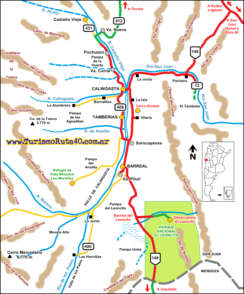
Side Trip to Rodeo and Calingasta from Ruta 40
Andean Valleys
From Ruta 40 in Talacasto you can drive to the Iglesia and Calingasta Valley along Provincial Higway 436, which is Paved.
Valley of Iglesia
See this Map of the area
It is 111 km to the north along Prov. Hwy 436 and Ruta 149 to the village of Iglesia.
From Iglesia you can continue along Ruta 150 (14 km) to reach the tourist town of Rodeo. Ruta Nac. 150 then heads west along a gravel surfaced roadway with the Agua Negra pass leading into Chile. Eastwards, along a paved road it closes the circuit, heading along the Cuesta del Viento reservoir on the Jáchal river, and reaching Jáchal (Map).
North of Rodeo, Prov. Hwy 430, which is not paved, heads into the wild, and barren San Guillermo National Park, a permit and guide are required to visit it.

Calingasta Valley
See this Map of the area
Taking Prov Hwy 436 and heading south along Ruta 149 you will reach Calingasta (117 km away) in the western part of San Juan, the highway continues south reaching Barreal and Leoncito National Park, 60 km further South. You can continue into Mendoza along this valley reaching Ruta 7 in Uspallata (Map).

Back to Ruta 40
From Talacasto, the Ruta 40 runs north along a segment with many dips (concrete slab fords) across dry river beds that cut across the highway with a west-to-east course. At km 271 Adán Quiroga.

On the east you can see the Sierra del Morado, west is the "Bolsón de Matagusanos" at the foot of the Talacasto Sierra.
At km 287 road to Tucunuco, 3 km east, on the Jáchal River, an old stop on the road between San Juan and San Juan a Jáchal.
The highway enters the irrigated Valley of the Jáchal River, reaching Niquivil (km 305), which was founded next to the railway station.

The village was an old Diaguita site; it was here that Lieutenant Domingo Faustino Sarmiento had his baptism of fire in a skirmish between his Unitarian group and Federal rebels in 1829.
To the right is the road to Niquivil Viejo. The fields here are irrigated for the next 10 km (6.2 mi) to San Roque where Ruta 40 meets Ruta 150 at the km 316 in the San Roque Roundabout. Here, Ruta 40 takes a right and then a left to head north into Huaco bypassing Jáchal.
At the roundabout Ruta 150 coming from the east (from Ischigualasto Park), heads north, goes and reaches San José de Jáchal (km 328).
Jáchal
As mentioned further up, from Jáchal you can drive along the paved Ruta Nacional 150 to Rodeo and also visit the San Guillermo National Park.

From Jáchal to Huaco
>> See our Interactive map (orange line)

Fill your gas tank in Jáchal. To head north along Ruta 40 into Huaco there are two options (see map):
One is using the modern, Ruta 40, the other is the old alignment of Ruta 40:
Old Ruta 40
Pictouresque and paved. Leave Jáchal (roundabout km 0), head north along Prov. Hwy 456, which crosses the Jáchal River and enters a farming area known as Pampa Vieja. Here were the old flour mills. At km 4 junction with Prov. Hwy 49, turn right eastwards towards the Church of Santa Rita and the Hill known as Piedra Blanca (km 10). The road curves north again, along the slope of the hill and climbs towards the reservoir (Dique Los Cauquenes) at km 16. Here it becomes winding and reaches the narrow tunnel (km 20 barely 4 m wide (12 ft.) and 100 m long (310 ft) cutting through the Sierra Negra.

Cuesta de Huaco (Huaco Slope)
After the tunnel you enter the Cuesta de Huaco and the higheay descends following the course of Huaco River towards the town of Huaco.
Ahead is the La Ciénaga campground, and at km 26 stop at the lookout point to take in the view of the slope, and hills (pictured below). The road winds with curves of 180° towards Huaco. There are eroded rocks that form figures like the Chair of the Giant (Sillón del Gigante -pictured further up).
Bridge over the river with a trail leading to the hot springs of Termas de Agua Hedionda (1 km), with sulfurous springs. Ahead is a small dam on the river. At km 31 Junction with Ruta 40 that comes from the right (south west) after having gone through Huaco. Here Ruta 40 turns north towards Guandacol.

To Huaco along the new alignment of Ruta 40
From the San Roque roundabout, head east along overlapping Ruta 40 and 150, crossing the Jáchal River.
The roadway curves north following the southern tip of the Sierra Negra and reaches the southern tip of the area irrigated by the Huaco River. Interchange at km 350: Ruta 40 continues north into Huaco, and Ruta 150 heads east to reach the Ischigualasto Provincial Park.
At km 356, Huaco, the village is 1 km to the east.

Huaco
Tiny village stopped in time, its name is Quechua, and means: Hua, "corn" and co, "water". Others say it is a Diaguita name for an aquatic bird.
Mill
Visit the ancient Molino Dojortí, a flour mill that belongs to the Daugherty family (which the locals pronounced "Dojortí"). They descend from a prisoner who was interned here during the English Invasions of Buenos Aires in 1806 and 1807. Later released, the British soldier chose to stay here in Huaco. One member of the family was a renowned folklorist, Buenaventura Luna (1906-1955), who is buried in the local cemetery.
Fiesta de la Tradición in Jáchal
A festival created to celebrate Don Buenaventura Luna. It takes place in November, with folkloric music, handicrafts, local food, and a float parade.
Huaco
>> Learn all about Huaco

> > Find your hotel in Huaco
Final leg to Guandacol
Head west from Huaco, and at km 359 the old Ruta 40 (now Prov. Hwy 49) meets the new alignment, turn right, northwards. This is a straight, flat, and lonely road with concrete slab fords every couple of hundred meters. The highway rises and dips as it crosses them.
Important: Rain
If it rains in the hills (to the west are the Sierras de Yanso), the water will rush down the dry slopes and gullies and cross these concrete fords. Even if it isn't raining on the highway it may rain in the hills. Mud, rocks, bushes and water will flow across the fords.

At km 412 entrance to the Gualcamayo mine, and at km 418 Border between San Juan and La Rioja provinces.
La Rioja
The highway enters the province of La Rioja. At km 426 is the village of Santa Clara and at km 429 crossroads that leads to Guandacol the town that marks the endpoint of this leg (km 432).
Guandacol
According to historian Lafone Quevedo, the name "Guandacol" blends three words: Huan: "dead"; Tacu: "tree", and Ullu: "penis". Father Cabrera says it is a Huarpe word where the word Tumta: "hill" was deformed by the Spaniards into "Umta", "Guamta", and "Guanda". The word Col is Quechua, from "Colque" meaning "silver": "silver hill".
The local Guandacol natives, a Diaguita group lived here. The town was established in 1607 as a grant ("merced") to Don Gaspar Doncel. The place was known as "merced de Mocaibin".
Next Leg, across La Rioja
See theNext Leg, from Guandacol to Alpasinche crossing La Rioja.
Tips and Advice for this Section
1. Weather

- Summer. Hot, daytime temperatures are high (high 30s° and more - over 100°F). Rainy season with downpours and hail.
- Winter. Cool during the day, cold at night. Dry season, clear skies, frost in open areas. The July school recess brings many visitors, but outside of that period, low season.
- Fall and Spring. Pleasant daytime, cool nights, not much rain. Zonda Wind (dry, hot, dusty) can be expected, blowing down the Andes.
2. When to Drive this leg?
You can visit it any time, the whole year round.
3. Take Care
Simple and easy to drive from Mendoza to Jáchal, but the final part, after Jachal, especially the Prov. Hwy 49 and Cuesta de Huaco is a narrow, winding, mountain road with hairpin bends. The road is paved, and it is a low altitude drive (1,000 m - 3,300 ft.).
Part of it is a divided highway; nevertheless, take care with motorcycles, pedestrians, stray animals, and cyclists.
The Andean and Andean Valleys have gravel roads. Drive with care.
Fords
During the summer rains, be aware of the forecast and remain alert for possible flooding.
Below is a normal ford, during the dry season:

Ford when the rainwater runs down the hills onto the highway:

Estado de la Ruta
Check road conditions on our webpage Road Conditions along Ruta 40.
Tips
- Carry a paper map, food, and water.
- Even in summer, if you plan on visiting the Andes, take warm clothes, a blanket, jacket. The weather can get cold and the wind can blow with strength..
There is fuel in Gran Mendoza, Jocolí, Media Agua, Gran San Juan, Guandacol and Jáchal
Learn more about the Service Stations on Ruta 40
Lodging on this Section
>> Find your hotel in Guandacol
Accommodation North to South
>> Find your hroom in San Juan Province


