
Ruta 40 Section 9

Ruta 40 entre Barrancas y Pareditas
This leg of Ruta 40 starts at the Barrancas River upstream from its confluence with the Grande River, as the highway enters Mendoza Province, it runs northwards through rugged, mountainous terrain, with lava flows, basaltic fields, and volcanoes. It ends at the souther tip of the wine-producing region of Valle de Uco.
A Summary of this Road Section
It covers a distance of 423 km (263 mi.).
Mostly paved section, but it has a nasty and long unpaved stretch south of Bardas Blancas.

Section 9, in Mendoza
See red box in map
This is a Map of the itinerary.
Paved and Gravel surface
This leg has paved sections and gravel segments awaiting to be paved: (from north to south)
- Río Barrancas - Jct. Ruta Prov. 221. Paved
- Empalme Ruta Prov. 221 - La Pasarela. Gravel
- La Pasarela - Bardas Blancas. Gravel
- Bardas Blancas - Malargüe. Paved
- Malargüe - El Sosneado. Paved
- El Sosneado - Pareditas Paved
How is the highway?
Learn all about the gravel section south of Malargüe
The largest city along this leg is Malargüe.
Heights along this segment
- 990 m (3,248 ft). At its starting pointBarrancas, Neuquén.
- 1,083 m (3,553 ft). At the end point, Pareditas, Mendoza.
Highest spot along this leg
The highway climbs from the Barrancas River and reaches its highest elevation of almost 2,000 m (6,565 ft) at the summit of the Cuesta del Chihuido incline, and then goes down towards Malargüe, with an elevation of 1.408 m (4,620 ft).
It climbs to 1.600 m (5,250 ft) at El Sosneado and reaches 1.900 m ( 6,233 ft.) at Arroyo La Faja creek, to descend towards Pareditas.
Mountain driving, winding road, risk of snow and ice in winter in the southern part of this leg.
Towns along this leg
These towns and communities are located along Ruta 40 from north to south: Pareditas, El Sosneado, Malargüe, Bardas Blancas, Ranquil del Norte, and Barrancas.
Map of this section of Ruta 40
Maps of the segment between Barrancas & Pareditas (N to S):
- Valle de Uco Pareditas, San Carlos, Tunuyán y Tupungato
- El Sosneado to Pareditas
- North and Central Mendoza
- El Sosneado
- Malargüe
Interactive Map of this Segment of Route 40
Barrancas: starting point
Barrancas
Full details on the town of > > Barrancas [our Spanish language webpage]
>> Find your hotel in Barrancas
We describe this section from South to North, beginning at the city of Barrancas and heading north, crossing the Barrancas River and leaving Neuquen province, and the Patagonia Region, to enter Mendoza Province, and Cuyo Region. This leg ends in Pareditas [our Spanish language webpage]
Leave Barrancas (km 0 of this leg), head for the bridge and cross the Barrancas river km 4. It flows from the NW towards the Grande River, and both meet and form the Colorado River, 15 km downstream from the bridge. On the north side of the river, you leave Patagonia and enter Cuyo Region's Mendoza province.
The highway starts climbing in a winding course towards the community of Ranquil del Norte. At km 15 junction on the left that leads to El Vatro.

At km 27 cemetery (right) and 1 km ahead is the tiny community of Ranquil del Norte (alt. 1,400 m - 4.593 ft.) To the NE you can see the volcanic summit of Cerro Payún (3,838 m - 12,592 ft.)
Ranquil del Norte
It offers services to the locals, it has a school, health provider, police, and grocery store. No fuel.
Towards Bardas Blancas
The road continues to climb and at km 42, it passes by a tiny lake, Coipo Lauquen (right). Its name in the Mapuche language means "lakes of the coipos"; a coipo is a rodent resembling a beaver or an otter. You may see black-necked swans. To the left, Provincial Hwy. 221 heads north. End of the paved roadway.
End of paved roadway. Gravel begins
Gravel roadway all the way to Bardas Blancas.
Ruta 40 heads east, winding and descending towards the Grande River that it crosses at km 63 in a spot called El Zampal.
Some views of this segment from RP 221 to La Pasarela
Click images for their street view

Along the Río Grande

At the Río Grande bridge, gravel

At the high part of the gravel road (1.600 m)

Gravel at the Jct. with RP 221
Land of volcanoes
From El Zampal, a road heads east (Ruta Prov. 180), into the El Payén Provincial Reserve, to the east, you can see some of the volcanoes of this area. Head left, along Ruta 40, on its eastern shore nortwards.
La Pasarela (The Footbridge)
Ruta 40 runs north along the river until it crosses it again at a spot called La Pasarela (km 93). The river runs, roaring between steep, sharp, black lava walls. There is a narrow wooden footbridge 100 m (300 ft.) north of the highway.
Río Grande
This is the river that carries most water in the whole province of Mendoza, it is born in the Andes, from glacial melt, and runs for 275 km (170 mi) with a volume of 110 m3 ⁄ seg - 3,885 cu.ft⁄sec

The lava at La Pasarela is of a dense type known as pahoehoe, which in the Hawaiian language means "suave". They resemble cords. When they cool, they have a wavy shape. These lava flows dammed the river, and the water wore it down some 41,000 years ago. See the volcanic cones on the western side of the river.
To the east is the Sierra de los Volcanes and beyond, the lonely Payen Matrú volcano with an elevation of 3.680 m (12,073 ft). It is a volcanic area with basalt fields and lava flows.
At km 102 (right) is a spot known as Buta Billón. At km 122 (left), junction with Prov. Hwy. 221 that comes from the south. At km 132 is a place known as Chalahuén. Ahead is the small village of Bardas Blancas where the paved roadway beginss:
Bardas Blancas
At km 150 you enter Bardas Blancas.
>> Read more about Bardas Blancas (Spanish)
>> Book your Hotel in Bardas Blancas
To the east is the paved National Highway 145 heading to the Paso Pehuenches mountain pass, which leads to Temuco, Chile.

Close to Bardas Blancas is a petrified forest with monkey puzzles. You can also visit a Provincial Reserve, the Cueva o Caverna de las Brujas (Witches Cavern), more below.

Caverna de las Brujas
This Provincial reserve is located on Cerro Moncol hill, and has several underground chambers. It is a karstic cave caused by the weathering of limestone due to water. Diluted carbonates and silicates have formed stalagmites and stalactites; some have names (the flowers, the crystals, the Virgin). It is a 260 meter-long (800 ft.) tour which can take roughly 2 hours.
Access. Leave Bardas Blancas, cross the river, and 2 km north to the left is the access road. It is 8 km (5 mi) from Ruta 40.
Tips. Wear comfortable shoes and warm clothes; the temperature in the cave is 10°C (50°F), and it is very humid (90%). Avoid it if you suffer from claustrophobia. Limited to groups of up 10 people.
Bardas Blancas to Malargüe
From here to Pareditas the road is paved all the way
Leave Bardas Blancas, cross the Rio Grande River, and head north. At km 167, spot known as Agua Botada. The highway climbs till it reaches an altitude of 1,994 m ( 6,542 ft.), at the Cuesta del Chihuido:
Cuesta del Chihuido (Slope of Chihuido)
>> Read more Cuesta del Chihuido [Spanish]
The road descends along 7 km (4.4 mi.) winding along the descent until it reaches its lowest point, with 1.750 m (5,742 ft.), in Manqui Malal at km 185.

Manqui Malal
Explore Fossils and waterfalls over 30 m (100 ft) high, a rappel, trekking spot. There is an inn (Parador el Chihuido).

Head nort, at km 197 junction (right) with Prov. Hwy 186 coming from the Reserva Provincial El Payén.
One of the Top 10 Attractions along Ruta 40
Payunia Provincial Reserve
>> Learn all about El Payén (English page)

At km 205 Loncoche Streamy, to your left the ruins of the Malal Hue Fort, National Historic Monument (NHM), three kilometers ahead, bridge crosses the Malargüe, River and you enter an area with farms. You reach the city of Malargüe (km 216).
Malargüe
>> Read more about Malargüe (Spanish).
Its name comes from two Mapuche native words that mean: Malal = pen, and hue = place; the "place of pens" where the natives kept their animals, enclosed in stone pens.
>> Book your Hotel in Malargüe
Local Landmarks
- Flour Mill (NHM). From the 19th century, it milled the wheat produced locally using water turbines.
- Pens with stone walls, at the homestead of Rufino Ortega. Site of rodeos (jineteadas) during the Fiesta del Chivo "Goat Festival".
- Malargüe River Dam. Good fishing spot.

- Malal Hue Fort (NHM). Mentioned above, 11 km south of the city. See its thick walls that are 2 m (6.6 ft.) thick.
- Handcrafts. Leather crafts are typical in this cattle-raising area.
- Castillos de Pinchieira. 18 km (11 mi) west. They are rock cliffs with fascinating shapes eroded by the wind. They resemble castles..
- Los Molles. 60 km north. Visit the thermal baths. The deep pond (Pozo de las ánimas) and a ski resort.
- Dinosaur footprints in an outdoor site near the town.
From Malargüe you can reach the Natural Reserve of Laguna de Llancanelo (60 km), a wetland that protects the local birds and animals in a volcanic setting.
>> Learn more about Llancanelo (Spanish)

Malargüe to El Sosneado

Head north from Malargüe, at km 228 El Chackay. Four kilometers ahead, junction (right) from La Junta.
Junction at km 246 that along Prov. Hwy 222 leads to the ski resort at the Valle de Las Leñas (49 km paved road), it takes you to the following spots:
Laguna Niña Encantada (Enchanted Girl Lagoon), Valle de los Molles, Pozo de las Animas (Well of the Spirits) and the ski resort of Las Leñas
>> Book your Hotel in Las Leñas or in Los Molles
Continue straight, cross the bridge over the Salado River. At km 256 Coihueco Norte. Ahead is Laguna Blanca with a camping site, and fishing options for silverside and trout. Birdwatching.
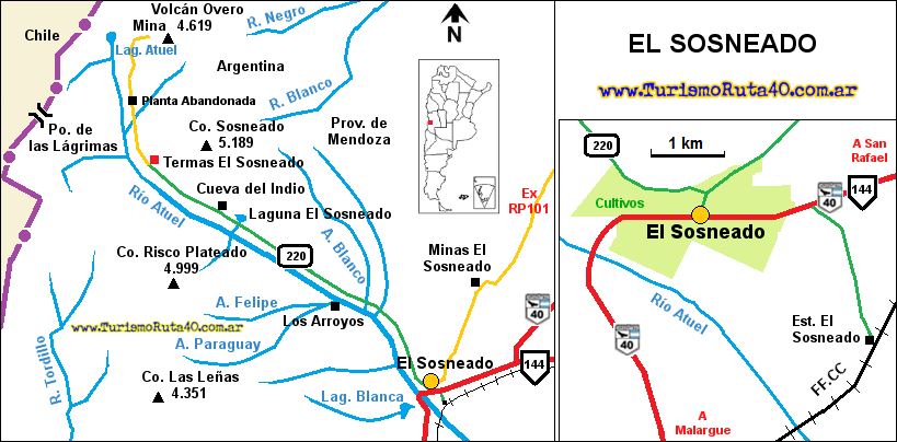
At km 264 bridge across the Atuel River, and just ahead (km 267) the village of El Sosneado.
El Sosneado
Small community on the side of the Atuel River on the foothills of the Andes. It has a service station, restaurant, police station, and lodging. You can also head into the Andes on a tour or ride horses.
From El Sosneado Prov. Hwy 220 heads west along the Atuel River Valley towards the ruins of the old El Sosneado Hot Springs, and the Cueva del Indio cave.
>> Read more abot El Sosneado (Spanish)

From El Sosneado to Pareditas
Paved, road segment that was built in 2019, when Rua 40 was realigned along Prov. Hwy 101, crossing the empty wilderness in this arid region. It bypassed the former longer route through San Rafael city (to the east).

The New section
This "New" roadway of Ruta 40 was opened in July 2019, shortening the distance between the city of Malargüe and Mendoza City by 100 km (62 mi). Avoiding the dogleg along the paved Rutas 144 and 143, and the older and longer gravel surfaced Ruta 40 further east.
From El Sosneado km 267 head east towards. Ahead (km 278) crossroads. Take a left, northwards along Ruta 40, leaving Ruta 144 that heads east.
The highway takes a northeast course. You can spot the black cinder cone of a volcano ahead. At km 332, descenst into the deep valley of the Diamante River.

Río Diamante River
It has its sources in Lake Diamante and runs along 360 km (224 mi.), The Mapuche called it Cla: "Three", Manque: "Condors" = Clamanque: "three condors", deformed by the Europeans to "Diamante".

The road heads straight north, and when it reaches the La Faja River (km 353), which it crosses with a wide curve and a modern bridge reaching the highest part of the valley at km 356 with 1,970 m (6,464 ft.)
It runs straight across the Pampa Amarilla crosses the Cortaderas Stream (km 375) and meets Prov. Hwy 98 that comes from the west at km 384. This road leads to the Maipo Volcano and Laguna del Diamante.
Maipo Volcano
Maipo Volcano has an elevation of 5,232 m (17,165 ft) and is set on the border with Chile. It is a stratovolcano that is currently inactive. The area round the volcano is a volcanic caldera, a large circular depression.

There is a hotspot roughly 20 km in diameter (12 mi.); it had an explosive eruption 450,000 years ago, ejecting a vast quantity of ashes. The current cone was formed much later and stands 1,900 m (6,300 ft.) above the lake that filled part of the caldera.
It was active between 1822 and 1941. The lava that flowed from the 1826 eruption dammed a river, and formed Lake Diamante.
The Name Maipo
From the Mapuche word Maipun, meaning cultivated land, named for a spot south of Santiago, Chile, watered by the Maipo River in Chile, which has its sources in the volcano..
Laguna del Diamante
The lagoon is set at the foot of the volcano and covers 14 km2 (5.4 sq. mi.) it freezes over in winter. The Diamante River has its sources here. It is relatively shallow (70 m - 210 ft). It measures 7 by 3 km ( 4.3 by 1.9 mi). Trout and silverside fishing spot. It is set at an elevation of 3,250 m (10,663 ft.)

Into Pareditas
After the road that leads to the volcano, continue straight northwards, at km 420 the road curves right and meets Ruta Nacional 143 coming from San Rafael. Turn left along Ruta 40 and at km 421 you enter Pareditas End Point of This Leg.
Pareditas
Pareditas (1,080 m - 3,543 ft.) has around 2.000 residents and has all the services a tourist may need: food, gasoline, and lodging.
>> Read more about Pareditas (Spanish)
The Name
Spanish for "small walls", these were stone enclosures for the animals at the local ranches built by the San Juan Nepomuceno fort that was erected in 1773.
>> Book your Hotel in Pareditas
It is located at the southern tip of the Valle de Uco, it is a farming area and also an important wine-producing region. It is famous for its oregano plantations.

San Rafael
This is a bustling city located east of El Sosneado. It was founded in 1805 by the fort of San Rafael, whose ruins can still be seen. It is the economic center of SW Mendoza province, and a wine-producing region. There are many outdoor activities and wine-tasting options.
> > Find your hotel in San Rafael
Tips and Advice for your Roadtrip
1. Weather
It can rain heavily in summer, and the snowmelt during summer can make dry gullies carry water. The climate is dry and can have wide temperature swings between day and night.
During winter, it can drop below freezing point, and in the Andes, the temperatures can dip to -15°C (5°F). South of Malargüe it can snow on the highway during winter.
The region has a dry continental climate with only 300 mm of rainfall per year (1 ft.); the month with the most rain is July with 38 mm (1.5 in). During summer the temperature can range from 11 to 28°C (52 to 82F) and in winter from 11 to -2.5°C (52 to 28F). Humidity is below 50%.
2. Safety Tips
Ruta 40 has areas with a gravel surface in parts of this leg.
Fill up your tank with gasoline before driving this section, top it up at each town.
The road crosses a steppe and area with mountains in the Andean foothills; it has curves, inclines, and is, in parts, a winding mountain road. South of Bardas Blancas, the gravel roadway can be rough; drive slowly and avoid slipping. Braking distances on gravel are longer, too.
South of Malargue, snow and ice during winter can appear in shady spots on the road. Drive with care.
Take water, food, a blanket, and warm clothes with you. Even in summer, they can come in handy if you have cold weather.
There is fuel in Malargüe, El Sosneado y Pareditas. Also in San Rafael, La Consulta, Tunuyán, Tupungato and San Carlos.
›› Learn more about Service Stations along Ruta 40
Lodging on this Section of Ruta 40
Find your hotel in any of the cities in the region:
Book your room
>> Accommodation in Malargüe
Hotels in Mendoza City and surrounding area
Lodging in Luján de Cuyo
Hotels in the Valle de Uco
Accommodation in the South
>> Find your hotel in Mendoza Province


