

Ruta 40 Section 12
La Ruta 40 in Northern Cuyo

Section 12 in Cuyo
see red box in map
Section 12
Ruta 40 crossing La Rioja
This leg of the Ruta 40 crosses La Rioja province from south to north, winding its way across the steep range of Sierra de Famatina along the Cuesta de Miranda slope. It is totally paved and gives access to natural scenic sites like the Talampaya National Park, the Ischigualasto Provincial Park (in San Juan) and the Nature Reserve of Laguna Brava (in the Andes); it ends in the "Valle Vicioso" (Delightful Valley) of the de los Sauces River.
A mountain journey which also passes by the vineyards and wineries of La Rioja.
Take in the sun, nature, and culture along Ruta Nacional 40 in La Rioja, Cuyo, Argentina

A Summary of this Road Section
- Starts in: Guandacol (La Rioja)
- Ends in: Alpasinche (La Rioja).
- Total Distance: 276 km (171 mi.)
- Roadway: fully paved
Heights along the road
- 1.140 m (3,740 ft). At the end of the section in Guandacol, La Rioja.
- 938 m - 3,075 ft. At its starting point in Alpasinche, La Rioja province.
Maximum elevation of the section
2,020 m (7,350 ft.) in la Cuesta de Miranda at Bordo Atravesado.
Features of this leg
It has an average elevation of 1.000 m (3,300 ft.) with its highest section in Miranda. The paved road and low altitude drive make it quite simple. The "old" dirt surfaced, narrow, winding road along the cliff in Miranda was very dangerous, but it has been replaced by a modern highway.
Ruta 40 has a north-south alignment through the central part of La Rioja province with great views of the 6,000-meter-high (20,000 ft.) Sierra de Famatina, and the Sierra de Velasco. It experiences heavy rainfall in summer, which can provoke flash floods and cut the road.
Map of this Segment of Route 40

More maps of La Rioja
Itinerary: Section 12
Across La Rioja and the Sierra de Famatina
Scenery near Guandacol

Guandacol: Starting point
Guandacol is the first village in La Rioja along Ruta 40, coming from the south. It is close to the community of Santa Clara. It was the territory of a Diaguita native group known as "Guandacoles" that the Spanish King handed over, with their land, as a grant in 1607, to Gaspar Doncel. In 1630 during the Calchaqui Wars that raged for almost one century (1560s-1660s), the Guandacoles fought against the Spaniards, were defeated, uprooted and moved to Famatina and San Juan.
Between 1814 and 1869 the village was a stopping point for the cattle sent across the Andes to the Copiapó mines in Chile.

One of General San Martín's Army groups left from Guandacol in 1817 as part of the Army of the Andes Campaign that expelled the Spanish Royalist Army from Chile. They crossed the pass of Come Caballos and contributed to the Independence of Chile. The old olive tree that saw those soldiers is still there in Guandacol.
Leave Guandacol
We describe this leg from south to north starting from Guandacol (km 0). Head towards Ruta 40 and at the junction (km 3) turn left and head north towards Villa Unión.
Ahead is the La Troya River (km 6), which feeds the Bermejo River to the southeast. The highway runs towards the northeast, crossing the Vallecito Encantado (km 11) with rock formations eroded by the wind.
To the west you can see the Sierra de Maz, and to the east, the Cerros Colorados (Red Hills) pictured below.

At km 42 Ruta 40 intersects Ruta Nacional 76. If you head left (west) along Rua 76, after 3 km (2 mi.) you will reach the town of Villa Unión, which offers all the necessary comforts for the tourists, it is a good base from which to visit Talampaya, Ishigualasto, the Andes and the Bermejo River valley.
Villa Unión
Tours from Villa Unión
From here you can visit the Natural Reserve of Laguna Brava in the highlands (Puna) in the Andes.

Villa Unión is an ideal place to stop at to visit the Talampaya National Park and the Ischigualasto Provincial Park
UNESCO World Heritage Sites and Natural Parks
One of the Top-10 spots of Ruta 40
Both parks form a UNESCO World Heritage Site, Talampaya is in La Rioja province, and is adjoined by Ischigualasto in San Juan province.
They preserve rock formations, fossils of dinosaurs, rock art, and native plants and animals. You can reach them from Ruta 40 in Jáchal, San Juan and Villa Unión , La Rioja.

Talampaya National Park
It was created in 1997 on a previous Provincial Park formed in 1975. It preserves archaeological and palaeontological sites and materials
- Surface: 215,000 ha. (531,200 acres)
- Location: South Central part of La Rioja, on the border with San Juan
Ischigualasto Natural Provincial Park
Established in 1971 to protect its palaeontological sites.
- Superficie: 62,916 ha. (155,470 acres)
- Location: Northeastern San Juan.
Back to Ruta 40
Towards Cuesta de Miranda
From the crossroads with Ruta 76, continue northwards along Ruta 40, at km 55 is Las Tucumanesas, at km 58 road towards Tres Cerros (left).
At km 67 junction (left) with the road leading to El Chuschin. To the north you can see the Sierras de Famatina and to the south, the Sierra de Talampaya.
At km 74 dirt road (Prov. Hwy 18) from Pagancillo located 21 km to the south on Ruta 76.
Ruta 40 reaches Puerto Alegre (km 76) and starts its climb into the mountains. At km 86 junction to the right leading to the village of Aicuña with a high ratio of albinos.
Cuesta de Miranda
One of Ruta 40's Top Ten stops

Km 90: Los Tambillos, where the Cuesta de Miranda begins.
From los Tambillos to Miranda the road runs for 27 km of which 11.5 km are part of the "incline" or "slope" (cuesta).
Until it was upgraded, paved, and straightened out in 2015, it had 320 curves. A narrow, winding and cliff-hanging dirt road..

The road climbs to reach its highest point (2.020 m) at Bordo Atravesado (km 101) and then heads downhill towards the Bajos de Santa Elena winding along the narrow canyon of the Miranda River.
The river flows downhill towards Santa Elena and is fed by the snowmelt of the glaciers on the Nevado de Famatina, whose maximum height is the Cerro General Belgrano with an elevation of 6.097 m (20,003 ft.).
Ruta 40 runs along the Sierra de Sañogasta on the eastern side of the narrow and winding canyon.
The UNESCO World Heritage Site of the Camino del Inca (Inca Trail) was built by the Natives across the mountains here, following an ancient route across the Cuesta de Miranda.
At Km 115 Miranda marks the end of the slope.
Cuesta de Miranda
>> Read all about La Cuesta de Miranda
To Chilecito
Ruta 40 continues east, downhill and at km 125 junction (left) with Prov. Hwy. 15 coming from Sañogasta, Guanchín and Chilecito.
Continue and at km 133 junction with Ruta Nacional 74 in Nonogasta.
This is a flat area, with the Famatina Mountains to the West, and the Sierra de Velasco to the east; it is known as the Bajos de Santa Elena. Turn left, northwards at the junction to reach Chilecito (km 148)
Chilecito
Chilecito is a large city with an elevation of 1,110 m (3,642 ft.) and 50,000 residents. It has interesting tourist landmarks like the Colonial Chapels (from the 18th century), and the Inca fort, the Mejicana Mine with its railway and cable-car system (a National Historic Monument), and the neighboring villages of Samay-Huasi, Nonogasta, and Sañogasta.


Two options to Head North Along Ruta 40

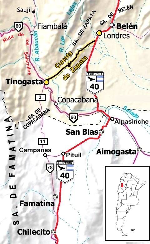
Map of the old, and new Ruta 40, and Cuesta de Zapata
A. Whittall
The map shows "new" alignment in red, and the "old" one with red arrows. (See them in our Interactive maps of the old roadway, and new roadway)
The "Old" and "New" Ruta 40
North of Chilecito, the highway forks at Famatina, one is the original alignment that headed to Tinogasta and was replaced in 1979, becoming Ruta Nacional 78, the other alignment, the current one, heads towards the Northeast, to San Blas de los Sauces and Alpasinche. You can connect between both at Campanas or Tinogasta.
- Famatina's. Original alignment of Ruta 40, now it is Ruta 78. It runs from Famatina to Campanas.
And continues to Tinogasta in Catamarca. It connects with the current Ruta 40 in Pituil. Alternatively, you can drive from Tinogasta along Ruta 60 to meet the new Ruta 40 and drive northward along Ruta 40 to Londres. - Current Ruta 40, from Chilectio to San Blas de los Sauces and Alpasinche.
1. Original road through Famatina along Ruta Nacional 78
Original Ruta 40
>> Read all about Original Ruta 40 from Famatina to Londres
Leave Chilecito towards the north along Ruta 40, crossing the Los Samientos River, straight, parallel to the mountain range, at km 152 is Los Sarmientos, ahead is San Nicolás (km 155). At km 170 fork to the west with the original Ruta 40 alignment (now Ruta 78).
Take Ruta 78 into Famatina, which is 11 km from the fork. Paved highway.
Famatina
>> Read all about Famatina
>> Book your hotel in Famatina

After famatina head north along Ruta 78 to the village of Campanas (km 229). Frome here you can take the original alignment of Ruta 40 (now Prov. Hwy 11 in La Rioja and Prov. Hwy 3 in Catamarca, to reach Tinogasta which is 63 km further north.
Tinogasta
City on Ruta 60, with many tourist stops and sights. It gives access to the Ruta de los Seismiles (Route of the Sixthousands), with towering 6,000 meter volcanos along the Andes towards the pass of San Francisco that leads to Chile. You can also take the Adobe Route that visits ancient chapels built in adobe.
Tinogasta
>> Read all about Tinogasta
>> Book your hotel in Tinogasta
From Campanas, you can take the Prov. Hwy 37 that goes through Chañarmuyo (km 237), and Pituil (km 252) closing a circuit and meeting the current alignment of Ruta 40.

San José chapel, Campanas, La Rioja. Austin Whittall
Campanas
Trivia. Close to this town is the cerro La Campanita (little bell hill), whose dark rocks, when struck, produce a sound similar to bells. The name of the town Campanas, means "bells" in Spanish.
The village has many colonial houses built in the 18th century, such as Lucía Carrizo's (1713) and Lorenzo Eizaguirre's (1770). Its church, pictured, is a National Historic Monument (NHM).
Chapel of San José de Campanas
Built in the 18th cdentury, it was restored with an Italian facade. It has Colonial images.
Chañarmuyo
In Diaguita language it means: Chañar : a typical tree of this area, and Muyo: "round".
Visit the winery, "Chañarmuyo Estate", with vines growing at 1,720 m (5,643 ft), a high altitude terroir on the foothills of the Paimán range. It has an inn.
>> Book your hotel in Chañarmuyo
2. To the "Valle Vicioso" - modern Ruta Nacional 40
From the fork in Famatina had north parallel to the Sierra de Velasco, to the east, where you can see Cerro Mesada (3,147 m 10.325 ft.)
At km 188 fork on road leads to Antinaco (left), to the east is the Cerro Paimán (2,771 m - 9,091 ft). The road is straight and at km 219 it reaches Pituil.
Pituil
Pituil was the most important Prehispanic settlement in the area. It is a fertile oasis irrigated by the Pituil River. Here it meets Prov. Hwy 39 coming from Campana (described further up).
The name is Quechua: pitu "flute" y huil "place": "Place of the flute".
Try the Vino Patero, made locally and fermented in the traditional ceramic pucas. They also distill the pomace to produce grappa.
Visit the ancient Mill, still operational, that ground wheat into flour.
Ruta 40 curves to the east and runs relatively flat and straight to reach the Valle Vicioso at km 253.
Valle Vicioso
So fertile and abundant in crops, its Spanish name means the Valley of "delights" or "abundance". The de los Sauces River irrigates the small villages along its course. These are, from south to north: Schaqui, Cuipán, Gualco o Hualco, Las Talas, Los Robles, and finally San Blas. Further south are Andolucas, with a campground and bathing spot on the river, Suriyaco, Amuschina, and Tuyuvil.
They form a rural area with over 5,000 residents known as Salicas - San Blas.

Diaguita Road Network
A branch of the Inca Trail (Camino del Inca) descended from Ciudacita in Tucumán, heading south. It was known as the ancient Road of Tucumanao.
It crossed the Paccipas Valley between Andalgalá and Alpasinche and was used until the 20th century to herd cattle. At Alpasinche it forked, une road went west into Catamarca, through Tinogasta to the San Francisco Pass in the Andes along the Colorado - Abaucán River to the town and site of Watungasta. (described in our Ruta del Adobe webpage). The other to Tucumán through "Los Baldes".
Close to the villageEn las proximidades de Alpasinche is the Inca fortification called pucará de Hualco, that protected the area.
Camino del Inca
>> Read all about the Inca Trail along Ruta 40: Camino del Inca
San Blas
At km 264 is the town of San Blas de los Sauces, the Capital city of the department. It was the most important native village in the Valley. The church dates back to 1732.
San Blas de Los Sauces
>> Read all about San Blas de Los Sauces
- San Blas Festival (patron saint). Celebrated on February 3 in the church.
- Pucará de Hualco. Visit the ruins of this Inca outpost on the Inca Trail - Camino del Inca.
- Cola de la novia. Waterfall on the river (Bride's veil)
Close to San Blas at the current village of "Bañados del Pantano" was a Spanish fort:
San Blas del Pantano Fort
A National Historic Monument, it was named "pantano" (bog, marsh) not because there was one, but because the fine sand was muddy. It was built in 1633 by Jerónimo Luis de Cabrera beside a Native "concentration camp" or "reducción" during the Calchaquí Wars.
You can still make out the adobe rooms and walls in the desert.
Final leg into Alpasinche
Leave San Blas, and cross Salicas, and Chaupihuasi to reach, at km 276 the village of Alpasinche, end of this leg.

Alpasinche
Its name means "brave land" and is set on the north-central part of La Rioja, at the foot of the Sierra de Velasco, with the Sauces river to the west and Ruta 60 to the north. Beyond it is the Salado River that is bound on the north by a vast closed basin, arid, and flat, the Campo de Belén.
Alpasinche was founded in 1740 by Don José Domingo de la Colina. There was a railway station on the now closed track of the Belgrano railroad that linked Tinogasta with the rest of the country (the narrow gauge tracks can be seen, rusting in the sand).
Visit the abandoned station, and the solid colonial church.
Alpasinche
>> Read all about Alpasinche

Side trip to Aimogasta
From Alpasinche, head west along Ruta 60 towards Aimogasta in La Rioja, it is the cradle of olives and the "National Capital of Olives". You can taste and buy different varieties of olives and olive oil.
National Historic Olive Tree
Close to Aimogasta, it was the only olive tree to survive the Royal Decree that ordered all olive trees to be felled to avoid competition with the olives produced in Spain. The locals saved this one, and it is the origin of the olive trees grwon in Southern South America. It is alive and still produces olives. It was planted in 1600 by the Conquistador Pedro de Alvarado.
>> Book your hotel in Aimogasta
Next Section: Ruta 40 in Catamarca
Ver el Next Leg, from Alpasinche to Santa María
Tips and Advice for this Section
1. Weather
You can visit it year round.
- Summer. Hot, with high daytime temperatures and low relative humidity. Rainy season with downpours and hail.
- Winter. Cool during the day, cold at night. Dry season, clear skies, frost in open areas. The July school recess brings many visitors, but outside of that period, low season.
- Fall and Spring. Pleasant daytime, cool nights. Warm and hot in October. Not rainy. Zonda Wind (dry, hot, dusty) can be expected, blowing down the Andes.
2. Precauciones
Fully paved, some mountain driving in Miranda. The gravel shoulders. The roads into the Andes or high elevation (like Laguna Brava), require more care.
Low altitude drive, but temperature swings are great.
Fords
During the summer rains, be aware of the forecast and remain alert for possible flooding.
Below is a normal ford, during the dry season:

Ford when the rainwater runs down the hills onto the highway:

Estado de la Ruta
Check road conditions on our webpage Road Conditions along Ruta 40.
Tips
- Carry a paper map, food, and water.
- Even in summer, if you plan on visiting the Andes, take warm clothes, a blanket, jacket. The weather can get cold and the wind can blow with strength..
There is fuel in Jáchal, Guandacol, Villa Unión, Nonogasta, Chilecito, San Blas de los Sauces, Aimogasta, Famatina, and Tinogasta.
Learn more about the Service Stations on Ruta 40
Lodging on this Section
Loding along Ruta 40 in La Rioja
There is accommodation in the cities and villages along the highway in the province, we list them from north to southa
Tu hotel en la zona
>> Find your Hotel in Chilecito
Hoteles along Ruta 40
Near Ruta 40 in La Rioja
South, in San Juan
North, in Catamarca
>> find your hotel en la La Rioja Province


