

Ruta 40 Section 14
Ruta 40 in the Calchaquí Valleys
This leg of the Ruta 40 between Santa María and Cachi is relatively flat. It is paved and easy in the first part, the Yokavil Valley (betrween Santa María and San Carlos).
Then it becomes a winding, narrow, gravel road that climbs up to Cachi along the Calchaquí River Valley linking ancient communities in an arid setting.
The itinerary includes a National Park with cacti, an amazing Moon-like landscape in the Quebrada de las Flechas (Canyon of the Arrows), vineyards, austere chapels, and a Native American culture.
Enjoy the scenery, food, wine, and people along Ruta Nacional 40 in the Valles Calchaquís of the North Region ofArgentina.

A Summary of this Road Section
It covers a distance of 236 km (1475 mi.).
The highway runs along the Prepuna region following the Valley of the Santa Marí River, known as Yokavil Valley to its confluence with the Calchaquí River in Cafayate, Salta. Then it climbs up the Calchaquí River Valley to Cachi.
It links Santa María in Catamarca with Cachi in Salta, and crosses the westernmost tip of Tucumán province.
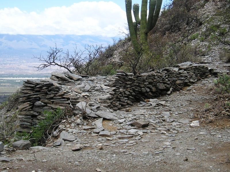
The Calchaquí Valley has a variable width, and the Ruta 40 crosses the river twice, close to Angastaco. The fields close to the river are green and irrigated. But the slopes of the mountains are dry, arid, and rocky.
Heights along the road
- 1,880 m (6,164 ft.) At its starting point: Sta. María, Catamarca.
- 2,880 m (9,442 ft.) At its ending point: Cachi, Salta.
Maximum elevation of the section
It reaches an elevation of 2,373 m (7,785 ft.) between Molinos and Seclantas, at a pass at km 202, in Salta.
It is a leg with moderate altitude with its lowest elevation at San Carlos with 1,600 m (5,250 ft.)
There are several communities along the route, that range from a few houses to towns,: From noth to south they are: Cachi, San José de Escalchi, Seclantás, Molinos, Angastaco, San Carlos, Animaná, Cafayate, Tolombón, Colalao del Valle, Fuerte Quemado, and Santa María.
Map of this Segment of Route 40

Section 14
see red box in map
More maps of this Area
Detail of the itinerary from Santa María to Cachi
Santa María: starting point
We describe this section from South to North, beginning at the city of Santa MaríaCachi [our Spanish language webpage] in Catamarca Province.
Leaving Santa María
Santa María is a town on the eastern side of the Santa Marí River. It is an ideal spot to use as a base to tour the archaeological sites of Yokavil Valley, and to take some side trips into Tucumán to visit the cities of Amaichá del Valle and Tafí del Valle.

Leave Santa María (km 0 of this leg), head west, cross the Santa María River, that runs along the southern tip of the Calchaqí Region; it flows with a northern direction towards Cafayate.
This part is known as Valle de Yocavil (or Yokavil). The road is paved.

Fuerte Quemado
After the bridge, at km 2 junction and roundabout at "Margarita Palacios", take a right, northwards. (See map). At km 12 is the community of Fuerte Quemado (Burned Fort), with a church and Prehispanic ruins. It owes its name to a Spanish fort that was razed during the bloody Guerras Calchaquíes a war that lasted 100 years, in the 16th and 17th centuries. After the town, at km 13 you leave Catamarca province and enter Tucumán province.
Ruta 40 in Tucumán
Trivia
This is the shortest stretch of Ruta 40 in the eleven provinces it crosses. It is only 57 km, 35.4 mi, long.
>> Learn more about Tucumán and its sights close to Ruta 40.
The highway keeps its northern course and at km 26 junction with Prov. Hwy RP 357 (right), it leads to the town of Aimachá del Valle (14 km), and up the Cumbres Calchaquíes range to cross the Abra del Infiernillo (Small Hell Pass) with an elevation of 3,042 m (9,980 ft.) to reach Tafí del Valle, and descends into the dense jungle on the eastern slopes of the mountains towards the capital city of Tucumán.
It is worth taking a side trip along Ruta Provincial 357 to visit both cities, Amaichá and Tafí del Valle:
Amaichá del Valle
>> Read more, full information onAmaichá del Valle and Tafí del Valle

>> Find your hotel in Amaicha del Valle or Tafí del Valle

Ruinas de los Quilmes (Quilmes Ruins)
Back on Ruta 40, after the junction, at km 29 to the left there is a gravel road at a fork; it is Prov. Hwy 357 leading to the Ruinas de los Quilmes archaeological site, 5 km (3.1 mi.)
Ruinas de los Quilmes
>> Read more, full information on Ruinas de los Quilmes
The ruins are part of a Prehispanic settlement of the Diaguita people that lived in this region, fighting against the Spaniards. They were defeated in a surprise winter campaign, and the inhabitants were rounded up and relocated. They were forced to walk to Buenos Aires! Where they were confined in a settlement that bears their name: Quilmes. Now it is a city in the Greater Buenos Aires metropolitan area, and a popular beer brand. Most of the natives died during their forced trek.

Keep north along the Ruta 40, which crosses many concrete slab fords over dips in the terrain that carry water duing the rainy summer season.

Colalao del Valle
At km 43 you reach the tiny village of Colalao del Valle.
> > Toda la información sobre Colalao del Valle
Close to Colalao is the hamlet of El Pichao which produces nuts and fruit. You can by textile handicrafts and jams. Next to it is the El Pichao archaeological site.
El Pichao archaeological site
Similar to the ruins at Los Quilmes, but these have not been restored, the stone walls are in a natural state. This site was occupied around 500 AD and the Calchaquí Wars wiped out the town.

Continue your journey, and at km 55 you leave Tucumán to enter Salta Province.
Salta and the Valles Calchaquíes

Tolombón church, Ruta 40, Salta
Ahead you cross Tolombón creek, and reach an area with vineyards and lines of poplars. At km 64 is the village of Tolombón.
Tolombón
With 500 residents. It is named for the tolombones, a Native American group that lived in this area, and whose chief, Juan Calchaquí began the rebelion that led to the "First Calchaquí War" (1561 - 63). It was also the headquarter of Halpa Inca or Bohórquez, who started the third and final Calchaquí War nearly one century later (1658).
Tolombón Ruins
Visit the ruins, 3 km from modern Tolombon, which are a National Historic Monumen (NHM). The site was inhabited between 900 AD and 1660 AD when the villaged was razed. It was the capital city of the Calchaquí people.
It has grain silos, water reservoir, houses that are partly built underground and a fort or "Pucará". It has been looted by visitors. A solo 3 km del pueblo, ha sido saqueado por los visitantes. (Map showing its location)

Into Cafayate
Leaving Tolombón's square and its austere church of the 19th century, head north. Ruta 40 passes by the Bodega Etchart winery, which offers tours. Cross the Loncohuasi River and reach Cafayate at km 77.
Cafayate
Cafayate is the most important city in the Valles Calchaquíes with hotels, restaurants, stores and many attractions. It is linked to the capital city of Salta along Ruta Nacional 68, paved (191 km - 119 mi.), which runs through the famous Quebrada de las Conchas. Top up your fuel tank, have lunch, visit the area.
Cafayate
>> Read more, full information on Cafayate
We strongly suggest visitng the wineries, tour the town on foot, and drive along Ruta 68 to visit the "Quebrada del río de las Conchas".
Cafayate is strategically placed at the confluence of the Calchaquí and Santa María rivers which then become the Las Conchas River that runs along the "Quebrada" or canyon, starting at the foot of Mount San Isidro.
There are vineyards and wineries around the city.

Views of the "Quebrada de las Conchas", Cafayate, Salta:


Ruta 40 from Cafayate to Cachi
As it leaves the city of Cafayate, the highway crosses the Chuscas River. La Rosa and Miguel Torino wineries are to the right. At km 80 junction with Ruta 68 that heads east to Salta City.
Head north along Ruta 40, which is paved upto San Carlos. You will see vineyards by the highway as you approach Animaná km 92 with several wineries (like Michel Torino), and production of traditional local wines. At km 102 is the village of San Carlos (See map):

San Carlos Village
The town is a National Historic Place (NHP), an old "pueblo de indios" (Indian village) with adobe houses. It was here that the natives razed several Spanish settlements during the Calchaquí Wars, like Barco (1551), Córdoba del Calchaquí (1559), San Clemente de la Nueva Sevilla (1557), and Nuestra Señora de Guadalupe (1630).
San Carlos
>> Read more, full information on San Carlos
Only after the wars, in the final years of the 18th century, did the Spaniards resettle the area. The Jesuits set up a mission in San Carlos, and the village grew around it. At that time, it was the trade center of the Valley (Cafayate was established later, in the mid 1800s). It vied with Salta to become the provincial capital, and was later overshadowed by Cafayate, closer to Salta, along the las Conchas river.
San Carlos Borromeo Church
It is a National Historic Monument (NHM) built in 1719 by Fernando de Lisperguer y Aguirre. Rebuilt in 1801. It is the largest in the Valley.

To Molinos and the Quebrada de las Flechas

Six kilometers north of San Carlos, is the access to the dam of La Dársena o San Carlos. Paved roadway ends at km 108
Along the dirt and gravel road you will see small hamlets with typical adobe and straw houses. The locals grow peppers, corn, and breed some cows and goats.
At km 114, Las Viñas, and at km 123 Chapel of Nuestra Señora de la Merced Valle Calchaquí, Our Lady of Mercy (pictured).
At km 127, Payogastilla, at km 130 bridge across the Calchaquí River. The road now runs along the eastern side of the river, crossing Santa Rosa and, at km 139 the highway crosses the river again at Piedras Pintadas, where a scenic drive begins.
Quebrada de Las Flechas ("Canyon of the Arrows")
"One of the Top 10 sights of Ruta 40"
A Stunning natural formation with eroded cliffs in tones of white, gray, and beige that jut out of the terrain in overlapping layers of strata that resemble gigantic arrowheads.
It is protected by the Natural Provincial Monument of Angastaco, and Ruta 40 runs through cuts in the rocks with names like The Glacier (El Ventisquero) , The Arrow (La Flecha), and The Canyon (El Cañón). (See map)
La Quebrada de las Flechas
>> Read more, full information on La Quebrada de las Flechas.
View of Ruta 40 (lower right) in the Quebrada de las Flechas


Angastaco
Just ahead is the tiny village of Angastaco, (km 151) to the left, close to Ruta 40.
El pueblo de Angastaco sobre la Ruta 40 sateñan, tiene dos iglesias y está junto a un antiguo pucará incaico. Es el lugar ideal para visitar la vecina Quebrada de las Flechas y conocer los Valles Calchaquíes. Caminatas, paseos, Los Colorados y El Carmen, son algunas cosas para ver y conocer.
Angastaco
>> Read more, full information on Angastaco

Continue along Ruta 40, crossing the Angastaco River, and at km 152 junction with Prov. Hwy 25 (left) towards Pucará and Colomé (see map). Continue straight.
At km 158, great view of the Valley and the El Carmen estate. Church of Carmen de Angastaco that dates back to 1800. The road crosses the las rosas creekm and at km 175, the hamlet of La Angostura.
The highway runs close to the river and reaches Humanao. Before the bridge over the Molinos river, at km 190 is the junction that leads, 3 km to the west, to the village of Molinos.

Molinos
Pueblo de Molinos Historic Site
The village is a NHP and was granted by the Spanish crown to Captain Diego Diez Gomez inn 1659 who lived there in a mansion.
Molinos
>> Read more, full information on Molinos
It is in the Valley by the confluence of the Luracatao and Humanao rivers that form the Molinos River. It has ancient adobe homes with galleries and porticos, corner doors and vineyards. From here you can drive into the mountains to visit the vineyards of Colomé and Tacuil.


, Molinos, Salta. Perla Eichenblat
San Pedro de Nolasco Church
It is a monument NHM, built in 1659 by Diego Diez Gómez. In Colonial Cuzco style. It holds the mummified remains of the last Spanish governor of Salta, Nicolás Severo de Isasmendi y Echalar. On the head of the doorway you can see a date: 1692.
Austere, with two towers, but a rich interior with a gilded altar and its roof was built with cardón cactus boards. The Patron Saint day is celebrated on February 2nd.
Colomé: The world's highest vineyard
To the southwest of Molinos is the estate, winery, and estancia Colomé, with top quality lodging. Its vines are planted at an elevation of 3,000 meters or 10,000 feet. They are said to be the highest vineyards in the world.
>> Book your lodging in the Estancia Colome
Colomé is the oldest winery in Argentina, established in 1831 by Nicolas Severo de Isasmendi. Some Malbec vines planted in 1854 are still bearing grapes.
From Molinos to Cachi
Head back to Ruta 40, take a left, northwards, crossing the Molinos River. At km 202 with 2.373 m (7,785 ft.) is the highest point of this leg.

At km 206, to the left, Prov. Hwy 56 to Brealito. Ahead, to the right is Seclantás along Prov. Hwy 42, just across the Calchaquí River.
Seclantás
Tiny village that grew around the church of Antonino Ibarguren, in the early 1800s, Nuestra Señora del Carmen.
Seclantás
>> Read more, full information on Seclantás
See the local weavers with their hand looms, local textile handicrafts.

Valley of the Caves - Cuevas de Acsibi
In Seclantas canyon, there are magnificent caves, known as Cuevas de Acsibi. There are tours to take you there. Along the Monte Nievas river there are colorful hills in tones of red, white, pink, and ochre. Their name in Diaguita language means "Place of fire" due to the colors of the rock.

Final leg to Cachi
Back to Ruta 40, the road runs along the irrigation channel that marks the edge of the cultivated fields by the river. At km 216 junction with Prov. Hwy 42 that crosses the river towards Tin-Tin and the Cuesta del Obispo (30 and 48 km respectively), both in the Cardones National Park, the road also heads south into Seclantas.
At km 221 San José de Escalchi, and at km 226, track that leads to an ancient site, La Paya, inhabited between 700 and 1600 AD.
Ahead, at km 233 the valley narrows as you enter Cachi which is located at km 236, endpoint of this segment.

Cachi
Located at an elevation of 2,280 m (7,480 ft.), Cachi was founded after the Calchaqui Wars by Governor Gonzalo de Abreu in 1670, where the Cachi and Calchaquí rivers met.
It is an ideal spot to stop and visit the High Calchaquí Valley, La Poma, and Cuesta del Obispo slope, Abra del Acay, and the Cardones National Park.
Cachi Village
The village was declared a NHP and was a grant belonging to the Aramburu family.

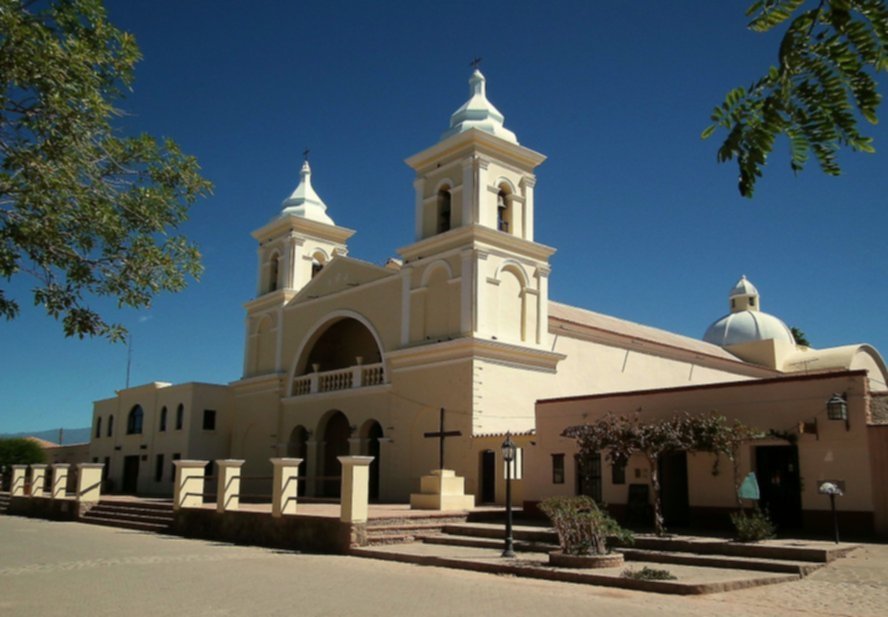
San José Church
The church is a NHM, it was the chapel of the Aramburus. In 1890, it was reformed, and restored in 1946. It has a single nave, and its roof is held up by cardon cactus beams, pictured below.

Next Segments
Tips & Advice: Visiting this region
1. Weather: in the "Valles Calchaquíes" and the Puna
Dry climate with very low relative humidity. It only rains in summer (Nov. to March). Wide temperature swing between day and night.
Rain can cut highways due to flash floods and mudslides.
Dry air and high altitude make for clear sunny skies the rest of the year. Use sunscreen.
Cold winters with frost and freezing temperatures.
2. Height: Mountain sickness
When you go above 6,500 feet (2.000 m), air pressure drops, reducing the content of oxygen. This may cause nasty symptoms such as fatigue, nausea, headache, dizziness, and confusion.
Learn how to mitigate the impact of Altitude Sickness
4. Safety Tips
The paved part to San Carlos is easy. However, north of it, the road to Cachi is gravel-surfaced, narrow, and winding. It has sharp curves. It crosses some dry river beds and has a rough surface.
The "dry" river beds that cut across the highway are dry most of the year but will turn into rushing rivers during flash floods in the rainy summer season.
Road Conditions
Check the road conditions on our website: Road Conditions.
- Keep your gas tank full (below we list the gas stations). Top it up before setting out and whenever you can. There are a few service stations in the area, and they may have run out of fuel.
- Take food and water with you. Carry a paper map - don't rely on the cell phone signal being available in the Puna.
- During the summer rainy season, there may be road closures on Ruta 40 and Rutas 9, 51, and 52
- Cross the fords carefully, especially during the summer flash flood season.
- This is a high altitude journey so factor in that you may suffer from Altitude Sickness.
- Wear appropriate clothes for the area (warm). Pack a blanket in case you have to spend the night out in the wilderness. Even in summer, it can get very cold at night (large day-to-night temperature swings).
Loose Gravel. Drive carefully on the gravel, it is slippery, you can skid, the dust may impair visibility, passing vehicles may fling stones at your windshield (cracking, chipping, or even breaking it. Take extra insurance when you rent a car).
There are Service Stations in Santa Marí Tafí del Valle, Amaichá del Valle, Cafayate, Seclantas y Cachi.
›› Location of Ruta 40's Service Stations
Accommodation on Ruta 40
Your hotel in the Valles Calchaquíes
>> Find your lodging in Cachi
Hotels in Salta along Ruta 40
Salta Hotels
North in Jujuy
South, along Ruta 40
>> Find your hotel in Provincia de Salta


.jpg)